You are here: Home > Network List > IU - Global Seismograph Network (GSN - IRIS/USGS) Stations List
> Station CCM Cathedral Cave, Missouri, USA > Earthquake Result Viewer
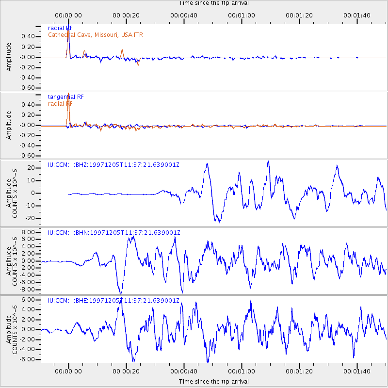
CCM Cathedral Cave, Missouri, USA - Earthquake Result Viewer

| Earthquake location: |
Near East Coast Of Kamchatka |
| Earthquake latitude/longitude: |
54.8/162.0 |
| Earthquake time(UTC): |
1997/12/05 (339) 11:26:54 GMT |
| Earthquake Depth: |
33 km |
| Earthquake Magnitude: |
6.3 MB, 7.6 MS, 7.9 UNKNOWN, 7.3 ME |
| Earthquake Catalog/Contributor: |
WHDF/NEIC |
|
| Network: |
IU Global Seismograph Network (GSN - IRIS/USGS) |
| Station: |
CCM Cathedral Cave, Missouri, USA |
| Lat/Lon: |
38.06 N/91.24 W |
| Elevation: |
222 m |
|
| Distance: |
68.3 deg |
| Az: |
54.447 deg |
| Baz: |
323.406 deg |
| Ray Param: |
0.056328185 |
| Estimated Moho Depth: |
34.75 km |
| Estimated Crust Vp/Vs: |
2.04 |
| Assumed Crust Vp: |
6.498 km/s |
| Estimated Crust Vs: |
3.189 km/s |
| Estimated Crust Poisson's Ratio: |
0.34 |
|
| Radial Match: |
98.28852 % |
| Radial Bump: |
259 |
| Transverse Match: |
87.610435 % |
| Transverse Bump: |
400 |
| SOD ConfigId: |
95591 |
| Insert Time: |
2010-03-04 15:45:14.144 +0000 |
| GWidth: |
2.5 |
| Max Bumps: |
400 |
| Tol: |
0.001 |
|
Signal To Noise
| Channel | StoN | STA | LTA |
| IU:CCM: :BHN:19971205T11:37:21.639001Z | 3.5321143 | 6.4098793E-7 | 1.8147429E-7 |
| IU:CCM: :BHE:19971205T11:37:21.639001Z | 3.4341965 | 8.3321527E-7 | 2.4262306E-7 |
| IU:CCM: :BHZ:19971205T11:37:21.639001Z | 4.896806 | 1.6358258E-6 | 3.340598E-7 |
| Arrivals |
| Ps | 5.7 SECOND |
| PpPs | 16 SECOND |
| PsPs/PpSs | 21 SECOND |


