You are here: Home > Network List > IU - Global Seismograph Network (GSN - IRIS/USGS) Stations List
> Station CCM Cathedral Cave, Missouri, USA > Earthquake Result Viewer
CCM Cathedral Cave, Missouri, USA - Earthquake Result Viewer

| Earthquake location: |
Near Coast Of Central Chile |
| Earthquake latitude/longitude: |
-31.0/-71.4 |
| Earthquake time(UTC): |
1998/01/12 (012) 10:14:07 GMT |
| Earthquake Depth: |
35 km |
| Earthquake Magnitude: |
5.8 MB, 6.2 MS, 6.6 UNKNOWN, 6.2 ME |
| Earthquake Catalog/Contributor: |
WHDF/NEIC |
|
| Network: |
IU Global Seismograph Network (GSN - IRIS/USGS) |
| Station: |
CCM Cathedral Cave, Missouri, USA |
| Lat/Lon: |
38.06 N/91.24 W |
| Elevation: |
222 m |
|
| Distance: |
71.1 deg |
| Az: |
343.558 deg |
| Baz: |
162.065 deg |
| Ray Param: |
0.054469533 |
| Estimated Moho Depth: |
45.0 km |
| Estimated Crust Vp/Vs: |
1.81 |
| Assumed Crust Vp: |
6.498 km/s |
| Estimated Crust Vs: |
3.595 km/s |
| Estimated Crust Poisson's Ratio: |
0.28 |
|
| Radial Match: |
95.32472 % |
| Radial Bump: |
281 |
| Transverse Match: |
71.84632 % |
| Transverse Bump: |
400 |
| SOD ConfigId: |
95591 |
| Insert Time: |
2010-03-04 15:45:22.088 +0000 |
| GWidth: |
2.5 |
| Max Bumps: |
400 |
| Tol: |
0.001 |
|
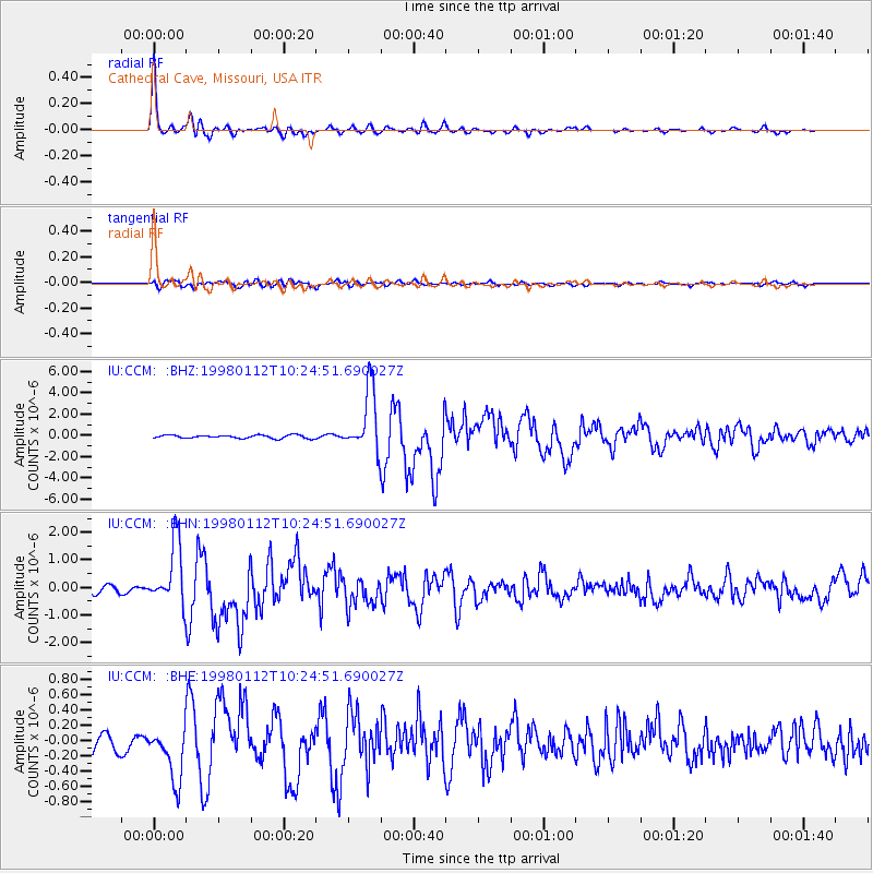
Signal To Noise
| Channel | StoN | STA | LTA |
| IU:CCM: :BHN:19980112T10:24:51.690027Z | 10.476198 | 1.1159007E-6 | 1.0651772E-7 |
| IU:CCM: :BHE:19980112T10:24:51.690027Z | 2.3729398 | 3.5046622E-7 | 1.4769284E-7 |
| IU:CCM: :BHZ:19980112T10:24:51.690027Z | 19.389666 | 2.9056775E-6 | 1.4985702E-7 |
| Arrivals |
| Ps | 5.8 SECOND |
| PpPs | 19 SECOND |
| PsPs/PpSs | 25 SECOND |


