You are here: Home > Network List > IU - Global Seismograph Network (GSN - IRIS/USGS) Stations List
> Station CCM Cathedral Cave, Missouri, USA > Earthquake Result Viewer
CCM Cathedral Cave, Missouri, USA - Earthquake Result Viewer

| Earthquake location: |
Central Bolivia |
| Earthquake latitude/longitude: |
-17.7/-65.4 |
| Earthquake time(UTC): |
1998/05/22 (142) 04:48:50 GMT |
| Earthquake Depth: |
24 km |
| Earthquake Magnitude: |
5.9 MB, 6.6 MS, 6.6 UNKNOWN, 6.2 ME |
| Earthquake Catalog/Contributor: |
WHDF/NEIC |
|
| Network: |
IU Global Seismograph Network (GSN - IRIS/USGS) |
| Station: |
CCM Cathedral Cave, Missouri, USA |
| Lat/Lon: |
38.06 N/91.24 W |
| Elevation: |
222 m |
|
| Distance: |
60.6 deg |
| Az: |
336.752 deg |
| Baz: |
151.54 deg |
| Ray Param: |
0.061417725 |
| Estimated Moho Depth: |
38.75 km |
| Estimated Crust Vp/Vs: |
1.91 |
| Assumed Crust Vp: |
6.498 km/s |
| Estimated Crust Vs: |
3.406 km/s |
| Estimated Crust Poisson's Ratio: |
0.31 |
|
| Radial Match: |
97.779366 % |
| Radial Bump: |
297 |
| Transverse Match: |
91.41459 % |
| Transverse Bump: |
400 |
| SOD ConfigId: |
95591 |
| Insert Time: |
2010-03-04 15:45:26.145 +0000 |
| GWidth: |
2.5 |
| Max Bumps: |
400 |
| Tol: |
0.001 |
|
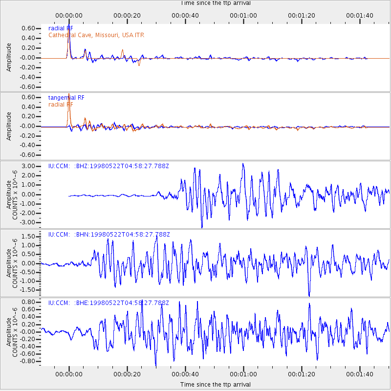
Signal To Noise
| Channel | StoN | STA | LTA |
| IU:CCM: :BHN:19980522T04:58:27.788Z | 1.1613365 | 6.669807E-8 | 5.7432164E-8 |
| IU:CCM: :BHE:19980522T04:58:27.788Z | 2.06304 | 9.161506E-8 | 4.44078E-8 |
| IU:CCM: :BHZ:19980522T04:58:27.788Z | 3.8172781 | 2.0591328E-7 | 5.3942436E-8 |
| Arrivals |
| Ps | 5.7 SECOND |
| PpPs | 17 SECOND |
| PsPs/PpSs | 22 SECOND |


