You are here: Home > Network List > TA - USArray Transportable Network (new EarthScope stations) Stations List
> Station J01E Myrtle Point, OR, USA > Earthquake Result Viewer
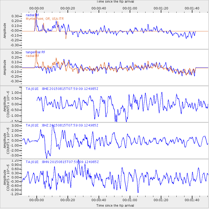
J01E Myrtle Point, OR, USA - Earthquake Result Viewer
*The percent match for this event was below the threshold and hence no stack was calculated.
| Earthquake location: |
Solomon Islands |
| Earthquake latitude/longitude: |
-10.9/163.9 |
| Earthquake time(UTC): |
2015/08/15 (227) 07:47:06 GMT |
| Earthquake Depth: |
6.4 km |
| Earthquake Magnitude: |
6.6 MWP, 6.6 MI |
| Earthquake Catalog/Contributor: |
NEIC PDE/NEIC COMCAT |
|
| Network: |
TA USArray Transportable Network (new EarthScope stations) |
| Station: |
J01E Myrtle Point, OR, USA |
| Lat/Lon: |
43.16 N/123.93 W |
| Elevation: |
128 m |
|
| Distance: |
84.7 deg |
| Az: |
44.395 deg |
| Baz: |
249.897 deg |
| Ray Param: |
$rayparam |
*The percent match for this event was below the threshold and hence was not used in the summary stack. |
|
| Radial Match: |
55.283363 % |
| Radial Bump: |
400 |
| Transverse Match: |
39.48702 % |
| Transverse Bump: |
400 |
| SOD ConfigId: |
7422571 |
| Insert Time: |
2019-04-20 10:59:49.551 +0000 |
| GWidth: |
2.5 |
| Max Bumps: |
400 |
| Tol: |
0.001 |
|
Signal To Noise
| Channel | StoN | STA | LTA |
| TA:J01E: :BHZ:20150815T07:59:09.124985Z | 3.6120496 | 1.0092405E-6 | 2.794094E-7 |
| TA:J01E: :BHN:20150815T07:59:09.124985Z | 1.0825593 | 3.085166E-7 | 2.8498815E-7 |
| TA:J01E: :BHE:20150815T07:59:09.124985Z | 1.0930508 | 3.2879606E-7 | 3.0080582E-7 |
| Arrivals |
| Ps | |
| PpPs | |
| PsPs/PpSs | |


