You are here: Home > Network List > TA - USArray Transportable Network (new EarthScope stations) Stations List
> Station N23A Red Feather Lakes, CO, USA > Earthquake Result Viewer
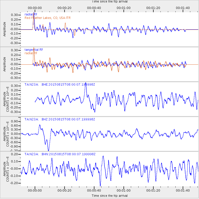
N23A Red Feather Lakes, CO, USA - Earthquake Result Viewer
*The percent match for this event was below the threshold and hence no stack was calculated.
| Earthquake location: |
Solomon Islands |
| Earthquake latitude/longitude: |
-10.9/163.9 |
| Earthquake time(UTC): |
2015/08/15 (227) 07:47:06 GMT |
| Earthquake Depth: |
6.4 km |
| Earthquake Magnitude: |
6.6 MWP, 6.6 MI |
| Earthquake Catalog/Contributor: |
NEIC PDE/NEIC COMCAT |
|
| Network: |
TA USArray Transportable Network (new EarthScope stations) |
| Station: |
N23A Red Feather Lakes, CO, USA |
| Lat/Lon: |
40.89 N/105.94 W |
| Elevation: |
2458 m |
|
| Distance: |
97.2 deg |
| Az: |
49.824 deg |
| Baz: |
261.86 deg |
| Ray Param: |
$rayparam |
*The percent match for this event was below the threshold and hence was not used in the summary stack. |
|
| Radial Match: |
74.429085 % |
| Radial Bump: |
400 |
| Transverse Match: |
69.460396 % |
| Transverse Bump: |
400 |
| SOD ConfigId: |
7422571 |
| Insert Time: |
2019-04-20 11:00:10.365 +0000 |
| GWidth: |
2.5 |
| Max Bumps: |
400 |
| Tol: |
0.001 |
|
Signal To Noise
| Channel | StoN | STA | LTA |
| TA:N23A: :BHZ:20150815T08:00:07.199998Z | 7.576343 | 3.174154E-7 | 4.1895596E-8 |
| TA:N23A: :BHN:20150815T08:00:07.199998Z | 0.8682567 | 3.6543998E-8 | 4.208893E-8 |
| TA:N23A: :BHE:20150815T08:00:07.199998Z | 2.5356297 | 1.5964251E-7 | 6.295971E-8 |
| Arrivals |
| Ps | |
| PpPs | |
| PsPs/PpSs | |


