You are here: Home > Network List > CI - Caltech Regional Seismic Network Stations List
> Station GLA Glamis, California, USA > Earthquake Result Viewer
GLA Glamis, California, USA - Earthquake Result Viewer
*The percent match for this event was below the threshold and hence no stack was calculated.
| Earthquake location: |
Mariana Islands |
| Earthquake latitude/longitude: |
14.2/144.9 |
| Earthquake time(UTC): |
1998/05/15 (135) 05:58:06 GMT |
| Earthquake Depth: |
154 km |
| Earthquake Magnitude: |
5.7 MB, 6.0 UNKNOWN, 6.0 MW |
| Earthquake Catalog/Contributor: |
WHDF/NEIC |
|
| Network: |
CI Caltech Regional Seismic Network |
| Station: |
GLA Glamis, California, USA |
| Lat/Lon: |
33.05 N/114.83 W |
| Elevation: |
627 m |
|
| Distance: |
90.8 deg |
| Az: |
55.731 deg |
| Baz: |
287.368 deg |
| Ray Param: |
$rayparam |
*The percent match for this event was below the threshold and hence was not used in the summary stack. |
|
| Radial Match: |
64.66232 % |
| Radial Bump: |
400 |
| Transverse Match: |
65.20218 % |
| Transverse Bump: |
400 |
| SOD ConfigId: |
4480 |
| Insert Time: |
2010-02-25 23:37:20.323 +0000 |
| GWidth: |
2.5 |
| Max Bumps: |
400 |
| Tol: |
0.001 |
|
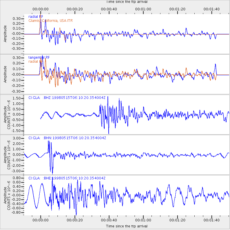
Signal To Noise
| Channel | StoN | STA | LTA |
| CI:GLA: :BHN:19980515T06:10:20.354004Z | 2.8016772 | 6.614525E-7 | 2.3609161E-7 |
| CI:GLA: :BHE:19980515T06:10:20.354004Z | 1.9145381 | 3.7213917E-7 | 1.9437543E-7 |
| CI:GLA: :BHZ:19980515T06:10:20.354004Z | 1.2724594 | 2.001227E-7 | 1.5727237E-7 |
| Arrivals |
| Ps | |
| PpPs | |
| PsPs/PpSs | |


