You are here: Home > Network List > UW - Pacific Northwest Regional Seismic Network Stations List
> Station IZEE Izee, OR, USA > Earthquake Result Viewer
IZEE Izee, OR, USA - Earthquake Result Viewer
| Earthquake location: |
Solomon Islands |
| Earthquake latitude/longitude: |
-10.9/163.9 |
| Earthquake time(UTC): |
2015/08/15 (227) 07:47:06 GMT |
| Earthquake Depth: |
6.4 km |
| Earthquake Magnitude: |
6.6 MWP, 6.6 MI |
| Earthquake Catalog/Contributor: |
NEIC PDE/NEIC COMCAT |
|
| Network: |
UW Pacific Northwest Regional Seismic Network |
| Station: |
IZEE Izee, OR, USA |
| Lat/Lon: |
44.08 N/119.50 W |
| Elevation: |
1293 m |
|
| Distance: |
88.1 deg |
| Az: |
44.548 deg |
| Baz: |
252.951 deg |
| Ray Param: |
0.042859033 |
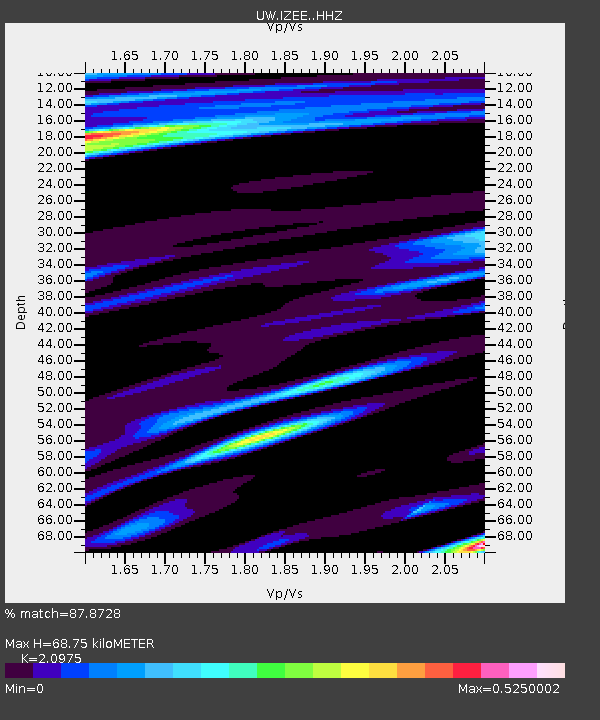
| Estimated Moho Depth: |
68.75 km |
| Estimated Crust Vp/Vs: |
2.10 |
| Assumed Crust Vp: |
6.571 km/s |
| Estimated Crust Vs: |
3.133 km/s |
| Estimated Crust Poisson's Ratio: |
0.35 |
|
| Radial Match: |
87.8728 % |
| Radial Bump: |
364 |
| Transverse Match: |
84.33881 % |
| Transverse Bump: |
400 |
| SOD ConfigId: |
7422571 |
| Insert Time: |
2019-04-20 11:01:31.747 +0000 |
| GWidth: |
2.5 |
| Max Bumps: |
400 |
| Tol: |
0.001 |
|

Signal To Noise
| Channel | StoN | STA | LTA |
| UW:IZEE: :HHZ:20150815T07:59:25.447983Z | 15.615139 | 9.145256E-7 | 5.85666E-8 |
| UW:IZEE: :HHN:20150815T07:59:25.447983Z | 1.2113991 | 8.1917634E-8 | 6.762234E-8 |
| UW:IZEE: :HHE:20150815T07:59:25.447983Z | 3.4725094 | 2.4904884E-7 | 7.172014E-8 |
| Arrivals |
| Ps | 12 SECOND |
| PpPs | 32 SECOND |
| PsPs/PpSs | 43 SECOND |


