You are here: Home > Network List > IU - Global Seismograph Network (GSN - IRIS/USGS) Stations List
> Station CCM Cathedral Cave, Missouri, USA > Earthquake Result Viewer
CCM Cathedral Cave, Missouri, USA - Earthquake Result Viewer
| Earthquake location: |
Turkey |
| Earthquake latitude/longitude: |
40.8/31.2 |
| Earthquake time(UTC): |
1999/11/12 (316) 16:57:19 GMT |
| Earthquake Depth: |
10 km |
| Earthquake Magnitude: |
6.3 MB, 7.5 MS, 7.2 MW, 6.6 ML |
| Earthquake Catalog/Contributor: |
WHDF/NEIC |
|
| Network: |
IU Global Seismograph Network (GSN - IRIS/USGS) |
| Station: |
CCM Cathedral Cave, Missouri, USA |
| Lat/Lon: |
38.06 N/91.24 W |
| Elevation: |
222 m |
|
| Distance: |
85.5 deg |
| Az: |
318.048 deg |
| Baz: |
40.038 deg |
| Ray Param: |
0.04469485 |
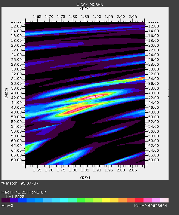
| Estimated Moho Depth: |
41.25 km |
| Estimated Crust Vp/Vs: |
1.89 |
| Assumed Crust Vp: |
6.498 km/s |
| Estimated Crust Vs: |
3.433 km/s |
| Estimated Crust Poisson's Ratio: |
0.31 |
|
| Radial Match: |
95.07737 % |
| Radial Bump: |
285 |
| Transverse Match: |
85.62298 % |
| Transverse Bump: |
400 |
| SOD ConfigId: |
87546 |
| Insert Time: |
2010-03-04 15:45:51.670 +0000 |
| GWidth: |
2.5 |
| Max Bumps: |
400 |
| Tol: |
0.001 |
|

Signal To Noise
| Channel | StoN | STA | LTA |
| IU:CCM:00:BHN:19991112T17:09:26.20802Z | 0.9323324 | 2.0373513E-7 | 2.1852199E-7 |
| IU:CCM:00:BHE:19991112T17:09:26.20802Z | 1.2810637 | 3.48301E-7 | 2.7188423E-7 |
| IU:CCM:00:BHZ:19991112T17:09:26.20802Z | 2.9037266 | 7.614481E-7 | 2.6223134E-7 |
| Arrivals |
| Ps | 5.8 SECOND |
| PpPs | 18 SECOND |
| PsPs/PpSs | 24 SECOND |


