You are here: Home > Network List > IU - Global Seismograph Network (GSN - IRIS/USGS) Stations List
> Station CCM Cathedral Cave, Missouri, USA > Earthquake Result Viewer
CCM Cathedral Cave, Missouri, USA - Earthquake Result Viewer

| Earthquake location: |
Off Coast Of Southern Chile |
| Earthquake latitude/longitude: |
-40.5/-74.8 |
| Earthquake time(UTC): |
1999/08/22 (234) 09:35:39 GMT |
| Earthquake Depth: |
33 km |
| Earthquake Magnitude: |
6.2 MB, 5.8 MS, 6.4 MW, 6.2 MW |
| Earthquake Catalog/Contributor: |
WHDF/NEIC |
|
| Network: |
IU Global Seismograph Network (GSN - IRIS/USGS) |
| Station: |
CCM Cathedral Cave, Missouri, USA |
| Lat/Lon: |
38.06 N/91.24 W |
| Elevation: |
222 m |
|
| Distance: |
79.6 deg |
| Az: |
346.834 deg |
| Baz: |
167.291 deg |
| Ray Param: |
0.04878164 |
| Estimated Moho Depth: |
34.75 km |
| Estimated Crust Vp/Vs: |
2.04 |
| Assumed Crust Vp: |
6.498 km/s |
| Estimated Crust Vs: |
3.193 km/s |
| Estimated Crust Poisson's Ratio: |
0.34 |
|
| Radial Match: |
98.06737 % |
| Radial Bump: |
261 |
| Transverse Match: |
90.347176 % |
| Transverse Bump: |
400 |
| SOD ConfigId: |
87546 |
| Insert Time: |
2010-03-04 15:46:04.836 +0000 |
| GWidth: |
2.5 |
| Max Bumps: |
400 |
| Tol: |
0.001 |
|
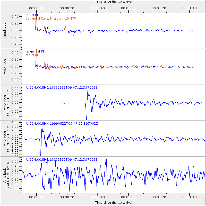
Signal To Noise
| Channel | StoN | STA | LTA |
| IU:CCM:00:BHN:19990822T09:47:12.397002Z | 28.207172 | 1.640308E-6 | 5.815216E-8 |
| IU:CCM:00:BHE:19990822T09:47:12.397002Z | 3.2213438 | 2.7223774E-7 | 8.451061E-8 |
| IU:CCM:00:BHZ:19990822T09:47:12.397002Z | 49.47249 | 4.484391E-6 | 9.0644136E-8 |
| Arrivals |
| Ps | 5.7 SECOND |
| PpPs | 16 SECOND |
| PsPs/PpSs | 22 SECOND |


