You are here: Home > Network List > XD14 - Illuminating the architecture of the greater Mount St. Helens magmatic systems f Stations List
> Station MO06 "Mount St Helens, WA" > Earthquake Result Viewer
MO06 "Mount St Helens, WA" - Earthquake Result Viewer
| Earthquake location: |
Solomon Islands |
| Earthquake latitude/longitude: |
-10.9/163.9 |
| Earthquake time(UTC): |
2015/08/15 (227) 07:47:06 GMT |
| Earthquake Depth: |
6.4 km |
| Earthquake Magnitude: |
6.6 MWP, 6.6 MI |
| Earthquake Catalog/Contributor: |
NEIC PDE/NEIC COMCAT |
|
| Network: |
XD Illuminating the architecture of the greater Mount St. Helens magmatic systems f |
| Station: |
MO06 "Mount St Helens, WA" |
| Lat/Lon: |
45.93 N/122.21 W |
| Elevation: |
784 m |
|
| Distance: |
86.8 deg |
| Az: |
42.193 deg |
| Baz: |
250.941 deg |
| Ray Param: |
0.043771695 |
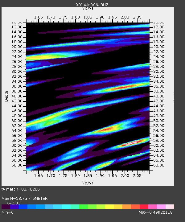
| Estimated Moho Depth: |
58.75 km |
| Estimated Crust Vp/Vs: |
2.03 |
| Assumed Crust Vp: |
6.566 km/s |
| Estimated Crust Vs: |
3.235 km/s |
| Estimated Crust Poisson's Ratio: |
0.34 |
|
| Radial Match: |
83.76286 % |
| Radial Bump: |
400 |
| Transverse Match: |
73.43592 % |
| Transverse Bump: |
400 |
| SOD ConfigId: |
7422571 |
| Insert Time: |
2019-04-20 11:02:39.206 +0000 |
| GWidth: |
2.5 |
| Max Bumps: |
400 |
| Tol: |
0.001 |
|

Signal To Noise
| Channel | StoN | STA | LTA |
| XD:MO06: :BHZ:20150815T07:59:19.449998Z | 5.1945114 | 9.059285E-7 | 1.744011E-7 |
| XD:MO06: :BHN:20150815T07:59:19.449998Z | 2.239639 | 2.1819027E-7 | 9.7422074E-8 |
| XD:MO06: :BHE:20150815T07:59:19.449998Z | 2.9235253 | 3.8950452E-7 | 1.3323111E-7 |
| Arrivals |
| Ps | 9.4 SECOND |
| PpPs | 27 SECOND |
| PsPs/PpSs | 36 SECOND |


