You are here: Home > Network List > IU - Global Seismograph Network (GSN - IRIS/USGS) Stations List
> Station CCM Cathedral Cave, Missouri, USA > Earthquake Result Viewer
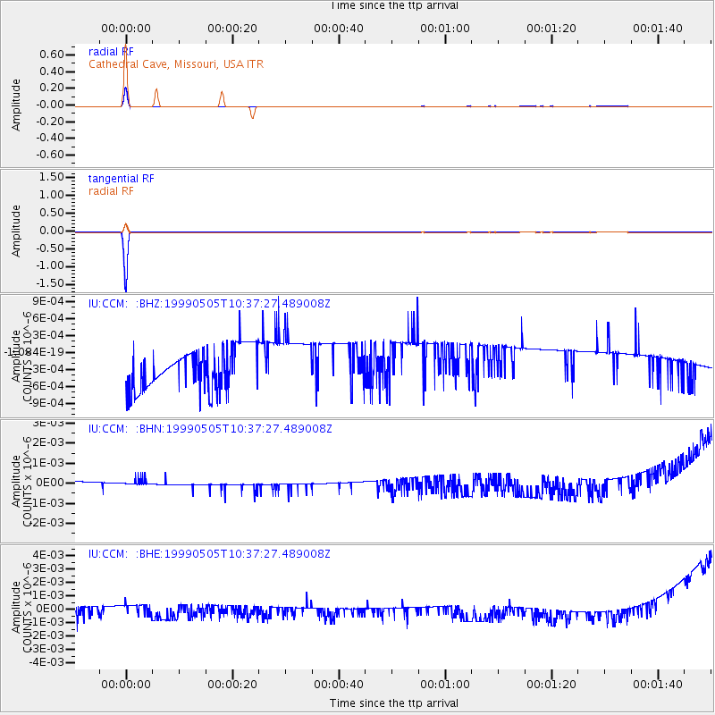
CCM Cathedral Cave, Missouri, USA - Earthquake Result Viewer
| Earthquake location: |
Kenai Peninsula, Alaska |
| Earthquake latitude/longitude: |
59.3/-151.5 |
| Earthquake time(UTC): |
1999/05/05 (125) 10:30:03 GMT |
| Earthquake Depth: |
71 km |
| Earthquake Magnitude: |
5.4 MB, 5.8 MW, 5.8 MW |
| Earthquake Catalog/Contributor: |
WHDF/NEIC |
|
| Network: |
IU Global Seismograph Network (GSN - IRIS/USGS) |
| Station: |
CCM Cathedral Cave, Missouri, USA |
| Lat/Lon: |
38.06 N/91.24 W |
| Elevation: |
222 m |
|
| Distance: |
43.3 deg |
| Az: |
91.743 deg |
| Baz: |
319.472 deg |
| Ray Param: |
0.07241137 |
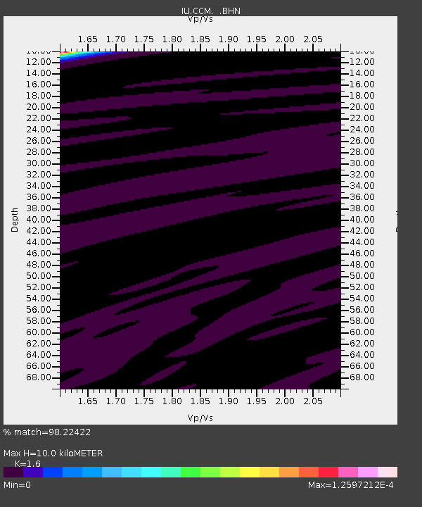
| Estimated Moho Depth: |
10.0 km |
| Estimated Crust Vp/Vs: |
1.60 |
| Assumed Crust Vp: |
6.498 km/s |
| Estimated Crust Vs: |
4.061 km/s |
| Estimated Crust Poisson's Ratio: |
0.18 |
|
| Radial Match: |
98.22422 % |
| Radial Bump: |
49 |
| Transverse Match: |
99.94012 % |
| Transverse Bump: |
14 |
| SOD ConfigId: |
87546 |
| Insert Time: |
2010-03-04 15:46:15.007 +0000 |
| GWidth: |
2.5 |
| Max Bumps: |
400 |
| Tol: |
0.001 |
|
Signal To Noise
| Channel | StoN | STA | LTA |
| IU:CCM: :BHN:19990505T10:37:27.489008Z | 0.77305585 | 3.612071E-10 | 4.672458E-10 |
| IU:CCM: :BHE:19990505T10:37:27.489008Z | 1.2138216 | 5.9015487E-10 | 4.8619575E-10 |
| IU:CCM: :BHZ:19990505T10:37:27.489008Z | 1.3237603 | 4.7588267E-10 | 3.5949307E-10 |
| Arrivals |
| Ps | 1.0 SECOND |
| PpPs | 3.7 SECOND |
| PsPs/PpSs | 4.7 SECOND |


