You are here: Home > Network List > YT07 - POLENET Stations List
> Station PECA PECA > Earthquake Result Viewer
PECA PECA - Earthquake Result Viewer
| Earthquake location: |
Solomon Islands |
| Earthquake latitude/longitude: |
-10.9/163.9 |
| Earthquake time(UTC): |
2015/08/15 (227) 07:47:06 GMT |
| Earthquake Depth: |
6.4 km |
| Earthquake Magnitude: |
6.6 MWP, 6.6 MI |
| Earthquake Catalog/Contributor: |
NEIC PDE/NEIC COMCAT |
|
| Network: |
YT POLENET |
| Station: |
PECA PECA |
| Lat/Lon: |
85.61 S/68.55 W |
| Elevation: |
1514 m |
|
| Distance: |
81.9 deg |
| Az: |
176.465 deg |
| Baz: |
231.847 deg |
| Ray Param: |
0.047283456 |
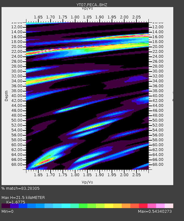
| Estimated Moho Depth: |
21.5 km |
| Estimated Crust Vp/Vs: |
1.68 |
| Assumed Crust Vp: |
6.39 km/s |
| Estimated Crust Vs: |
3.809 km/s |
| Estimated Crust Poisson's Ratio: |
0.22 |
|
| Radial Match: |
83.28305 % |
| Radial Bump: |
400 |
| Transverse Match: |
67.063065 % |
| Transverse Bump: |
400 |
| SOD ConfigId: |
7422571 |
| Insert Time: |
2019-04-20 11:04:07.124 +0000 |
| GWidth: |
2.5 |
| Max Bumps: |
400 |
| Tol: |
0.001 |
|

Signal To Noise
| Channel | StoN | STA | LTA |
| YT:PECA: :BHZ:20150815T07:58:54.02501Z | 2.9045837 | 5.1885945E-7 | 1.786347E-7 |
| YT:PECA: :BHN:20150815T07:58:54.02501Z | 2.035224 | 3.415938E-7 | 1.6784088E-7 |
| YT:PECA: :BHE:20150815T07:58:54.02501Z | 1.0496569 | 1.7677799E-7 | 1.6841501E-7 |
| Arrivals |
| Ps | 2.3 SECOND |
| PpPs | 8.8 SECOND |
| PsPs/PpSs | 11 SECOND |


