You are here: Home > Network List > ZJ12 - Transantarctic Mountains Northern Network Stations List
> Station SAMH East Antarctica > Earthquake Result Viewer
SAMH East Antarctica - Earthquake Result Viewer
| Earthquake location: |
Solomon Islands |
| Earthquake latitude/longitude: |
-10.9/163.9 |
| Earthquake time(UTC): |
2015/08/15 (227) 07:47:06 GMT |
| Earthquake Depth: |
6.4 km |
| Earthquake Magnitude: |
6.6 MWP, 6.6 MI |
| Earthquake Catalog/Contributor: |
NEIC PDE/NEIC COMCAT |
|
| Network: |
ZJ Transantarctic Mountains Northern Network |
| Station: |
SAMH East Antarctica |
| Lat/Lon: |
75.20 S/154.00 E |
| Elevation: |
2087 m |
|
| Distance: |
64.5 deg |
| Az: |
182.8 deg |
| Baz: |
10.76 deg |
| Ray Param: |
0.058881894 |
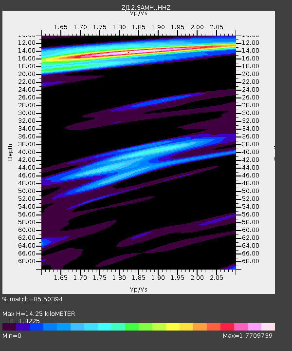
| Estimated Moho Depth: |
14.25 km |
| Estimated Crust Vp/Vs: |
1.82 |
| Assumed Crust Vp: |
6.262 km/s |
| Estimated Crust Vs: |
3.436 km/s |
| Estimated Crust Poisson's Ratio: |
0.28 |
|
| Radial Match: |
85.50394 % |
| Radial Bump: |
400 |
| Transverse Match: |
80.353806 % |
| Transverse Bump: |
400 |
| SOD ConfigId: |
7422571 |
| Insert Time: |
2019-04-20 11:04:25.411 +0000 |
| GWidth: |
2.5 |
| Max Bumps: |
400 |
| Tol: |
0.001 |
|

Signal To Noise
| Channel | StoN | STA | LTA |
| ZJ:SAMH: :HHZ:20150815T07:57:11.710007Z | 4.898578 | 1.4676217E-6 | 2.9960154E-7 |
| ZJ:SAMH: :HHN:20150815T07:57:11.710007Z | 1.8628607 | 5.382116E-7 | 2.889167E-7 |
| ZJ:SAMH: :HHE:20150815T07:57:11.710007Z | 1.2577163 | 3.27499E-7 | 2.603918E-7 |
| Arrivals |
| Ps | 1.9 SECOND |
| PpPs | 6.2 SECOND |
| PsPs/PpSs | 8.1 SECOND |


