You are here: Home > Network List > IU - Global Seismograph Network (GSN - IRIS/USGS) Stations List
> Station CCM Cathedral Cave, Missouri, USA > Earthquake Result Viewer
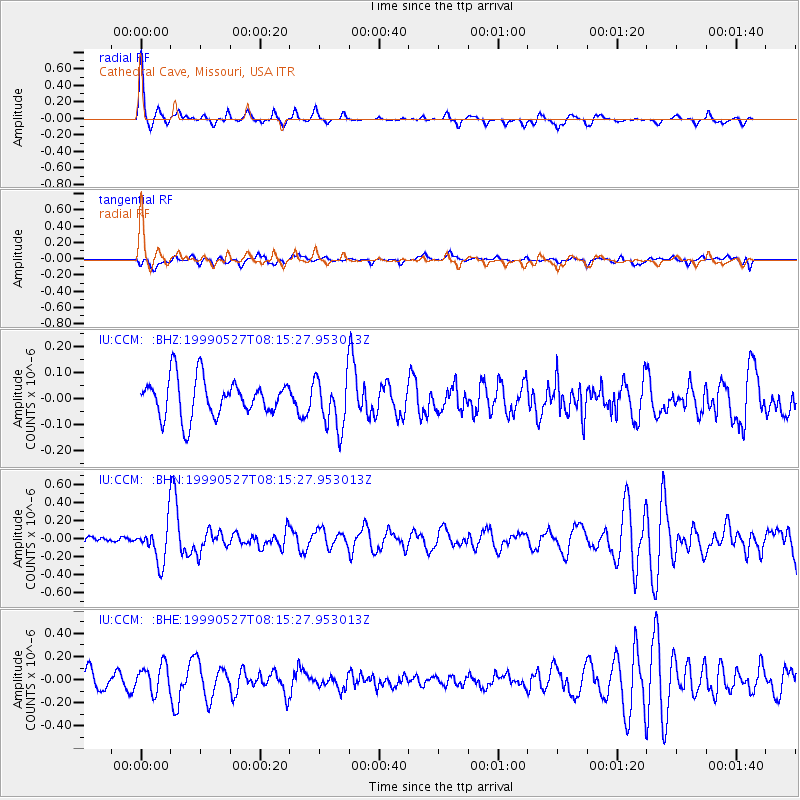
CCM Cathedral Cave, Missouri, USA - Earthquake Result Viewer
*The percent match for this event was below the threshold and hence no stack was calculated.
| Earthquake location: |
Southeastern Alaska |
| Earthquake latitude/longitude: |
58.7/-137.2 |
| Earthquake time(UTC): |
1999/05/27 (147) 08:08:58 GMT |
| Earthquake Depth: |
10 km |
| Earthquake Magnitude: |
5.5 MB, 5.2 MS, 5.8 MW, 5.4 ML |
| Earthquake Catalog/Contributor: |
WHDF/NEIC |
|
| Network: |
IU Global Seismograph Network (GSN - IRIS/USGS) |
| Station: |
CCM Cathedral Cave, Missouri, USA |
| Lat/Lon: |
38.06 N/91.24 W |
| Elevation: |
222 m |
|
| Distance: |
35.9 deg |
| Az: |
104.534 deg |
| Baz: |
320.13 deg |
| Ray Param: |
$rayparam |
*The percent match for this event was below the threshold and hence was not used in the summary stack. |
|
| Radial Match: |
72.5888 % |
| Radial Bump: |
342 |
| Transverse Match: |
53.846924 % |
| Transverse Bump: |
400 |
| SOD ConfigId: |
4480 |
| Insert Time: |
2010-03-04 15:47:45.564 +0000 |
| GWidth: |
2.5 |
| Max Bumps: |
400 |
| Tol: |
0.001 |
|
Signal To Noise
| Channel | StoN | STA | LTA |
| IU:CCM: :BHN:19990527T08:15:27.953013Z | 3.3820162 | 2.149906E-7 | 6.356877E-8 |
| IU:CCM: :BHE:19990527T08:15:27.953013Z | 1.311005 | 1.16463994E-7 | 8.883566E-8 |
| IU:CCM: :BHZ:19990527T08:15:27.953013Z | 1.3779104 | 1.00996964E-7 | 7.3297194E-8 |
| Arrivals |
| Ps | |
| PpPs | |
| PsPs/PpSs | |


