You are here: Home > Network List > IU - Global Seismograph Network (GSN - IRIS/USGS) Stations List
> Station CCM Cathedral Cave, Missouri, USA > Earthquake Result Viewer
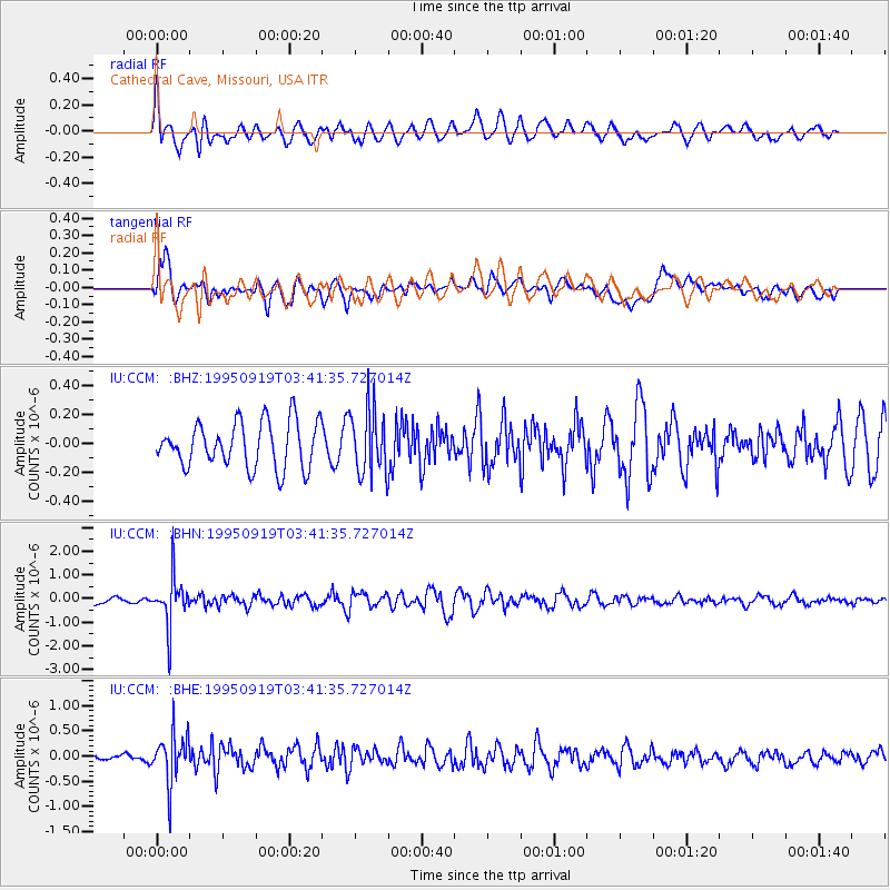
CCM Cathedral Cave, Missouri, USA - Earthquake Result Viewer
*The percent match for this event was below the threshold and hence no stack was calculated.
| Earthquake location: |
Chile-Bolivia Border Region |
| Earthquake latitude/longitude: |
-21.2/-68.7 |
| Earthquake time(UTC): |
1995/09/19 (262) 03:31:53 GMT |
| Earthquake Depth: |
110 km |
| Earthquake Magnitude: |
5.7 MB, 5.7 UNKNOWN, 5.6 MW |
| Earthquake Catalog/Contributor: |
WHDF/NEIC |
|
| Network: |
IU Global Seismograph Network (GSN - IRIS/USGS) |
| Station: |
CCM Cathedral Cave, Missouri, USA |
| Lat/Lon: |
38.06 N/91.24 W |
| Elevation: |
222 m |
|
| Distance: |
62.6 deg |
| Az: |
340.112 deg |
| Baz: |
156.294 deg |
| Ray Param: |
$rayparam |
*The percent match for this event was below the threshold and hence was not used in the summary stack. |
|
| Radial Match: |
62.199844 % |
| Radial Bump: |
400 |
| Transverse Match: |
51.557777 % |
| Transverse Bump: |
400 |
| SOD ConfigId: |
4480 |
| Insert Time: |
2010-03-04 15:47:52.056 +0000 |
| GWidth: |
2.5 |
| Max Bumps: |
400 |
| Tol: |
0.001 |
|
Signal To Noise
| Channel | StoN | STA | LTA |
| IU:CCM: :BHN:19950919T03:41:35.727014Z | 6.9000235 | 1.0278629E-6 | 1.4896513E-7 |
| IU:CCM: :BHE:19950919T03:41:35.727014Z | 5.402237 | 4.9131575E-7 | 9.094673E-8 |
| IU:CCM: :BHZ:19950919T03:41:35.727014Z | 1.4466002 | 2.282058E-7 | 1.577532E-7 |
| Arrivals |
| Ps | |
| PpPs | |
| PsPs/PpSs | |


