You are here: Home > Network List > IU - Global Seismograph Network (GSN - IRIS/USGS) Stations List
> Station CCM Cathedral Cave, Missouri, USA > Earthquake Result Viewer
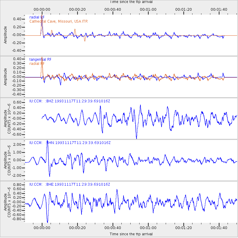
CCM Cathedral Cave, Missouri, USA - Earthquake Result Viewer
*The percent match for this event was below the threshold and hence no stack was calculated.
| Earthquake location: |
Near East Coast Of Kamchatka |
| Earthquake latitude/longitude: |
51.8/158.7 |
| Earthquake time(UTC): |
1993/11/17 (321) 11:18:52 GMT |
| Earthquake Depth: |
44 km |
| Earthquake Magnitude: |
6.0 MB, 5.6 MS |
| Earthquake Catalog/Contributor: |
WHDF/NEIC |
|
| Network: |
IU Global Seismograph Network (GSN - IRIS/USGS) |
| Station: |
CCM Cathedral Cave, Missouri, USA |
| Lat/Lon: |
38.06 N/91.24 W |
| Elevation: |
222 m |
|
| Distance: |
71.8 deg |
| Az: |
51.335 deg |
| Baz: |
322.111 deg |
| Ray Param: |
$rayparam |
*The percent match for this event was below the threshold and hence was not used in the summary stack. |
|
| Radial Match: |
69.89578 % |
| Radial Bump: |
400 |
| Transverse Match: |
65.91077 % |
| Transverse Bump: |
338 |
| SOD ConfigId: |
4480 |
| Insert Time: |
2010-03-04 15:47:56.082 +0000 |
| GWidth: |
2.5 |
| Max Bumps: |
400 |
| Tol: |
0.001 |
|
Signal To Noise
| Channel | StoN | STA | LTA |
| IU:CCM: :BHN:19931117T11:29:39.691016Z | 4.8138943 | 1.1100353E-6 | 2.3058989E-7 |
| IU:CCM: :BHE:19931117T11:29:39.691016Z | 2.701221 | 4.1053826E-7 | 1.5198249E-7 |
| IU:CCM: :BHZ:19931117T11:29:39.691016Z | 2.0593078 | 2.5112368E-7 | 1.2194569E-7 |
| Arrivals |
| Ps | |
| PpPs | |
| PsPs/PpSs | |


