You are here: Home > Network List > TA - USArray Transportable Network (new EarthScope stations) Stations List
> Station J04D Umpqua National Forest, Toketee, OR, USA > Earthquake Result Viewer
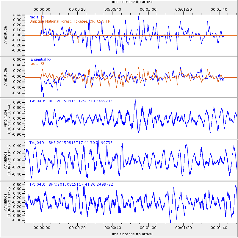
J04D Umpqua National Forest, Toketee, OR, USA - Earthquake Result Viewer
*The percent match for this event was below the threshold and hence no stack was calculated.
| Earthquake location: |
Kermadec Islands Region |
| Earthquake latitude/longitude: |
-27.3/-176.3 |
| Earthquake time(UTC): |
2015/08/15 (227) 17:29:23 GMT |
| Earthquake Depth: |
21 km |
| Earthquake Magnitude: |
5.5 MW |
| Earthquake Catalog/Contributor: |
ISC/ISC |
|
| Network: |
TA USArray Transportable Network (new EarthScope stations) |
| Station: |
J04D Umpqua National Forest, Toketee, OR, USA |
| Lat/Lon: |
43.24 N/122.11 W |
| Elevation: |
1948 m |
|
| Distance: |
86.0 deg |
| Az: |
36.423 deg |
| Baz: |
226.326 deg |
| Ray Param: |
$rayparam |
*The percent match for this event was below the threshold and hence was not used in the summary stack. |
|
| Radial Match: |
46.99626 % |
| Radial Bump: |
400 |
| Transverse Match: |
64.631615 % |
| Transverse Bump: |
400 |
| SOD ConfigId: |
7422571 |
| Insert Time: |
2019-04-20 11:20:33.008 +0000 |
| GWidth: |
2.5 |
| Max Bumps: |
400 |
| Tol: |
0.001 |
|
Signal To Noise
| Channel | StoN | STA | LTA |
| TA:J04D: :BHZ:20150815T17:41:30.249973Z | 0.86885035 | 1.5552361E-7 | 1.7899931E-7 |
| TA:J04D: :BHN:20150815T17:41:30.249973Z | 1.2419841 | 2.5567232E-7 | 2.0585796E-7 |
| TA:J04D: :BHE:20150815T17:41:30.249973Z | 0.77819586 | 1.6893443E-7 | 2.1708473E-7 |
| Arrivals |
| Ps | |
| PpPs | |
| PsPs/PpSs | |


