You are here: Home > Network List > II - Global Seismograph Network (GSN - IRIS/IDA) Stations List
> Station KAPI Kappang, Sulawesi, Indonesia > Earthquake Result Viewer
KAPI Kappang, Sulawesi, Indonesia - Earthquake Result Viewer
| Earthquake location: |
South Island, New Zealand |
| Earthquake latitude/longitude: |
-42.1/173.0 |
| Earthquake time(UTC): |
2015/04/24 (114) 03:36:43 GMT |
| Earthquake Depth: |
55 km |
| Earthquake Magnitude: |
5.9 MWP |
| Earthquake Catalog/Contributor: |
NEIC PDE/NEIC COMCAT |
|
| Network: |
II Global Seismograph Network (GSN - IRIS/IDA) |
| Station: |
KAPI Kappang, Sulawesi, Indonesia |
| Lat/Lon: |
5.01 S/119.75 E |
| Elevation: |
300 m |
|
| Distance: |
59.9 deg |
| Az: |
292.652 deg |
| Baz: |
136.395 deg |
| Ray Param: |
0.061758325 |
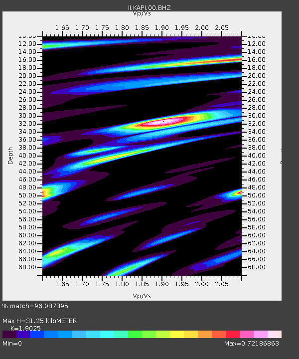
| Estimated Moho Depth: |
31.25 km |
| Estimated Crust Vp/Vs: |
1.90 |
| Assumed Crust Vp: |
6.343 km/s |
| Estimated Crust Vs: |
3.334 km/s |
| Estimated Crust Poisson's Ratio: |
0.31 |
|
| Radial Match: |
96.087395 % |
| Radial Bump: |
400 |
| Transverse Match: |
90.00205 % |
| Transverse Bump: |
400 |
| SOD ConfigId: |
872571 |
| Insert Time: |
2015-05-08 03:56:56.792 +0000 |
| GWidth: |
2.5 |
| Max Bumps: |
400 |
| Tol: |
0.001 |
|
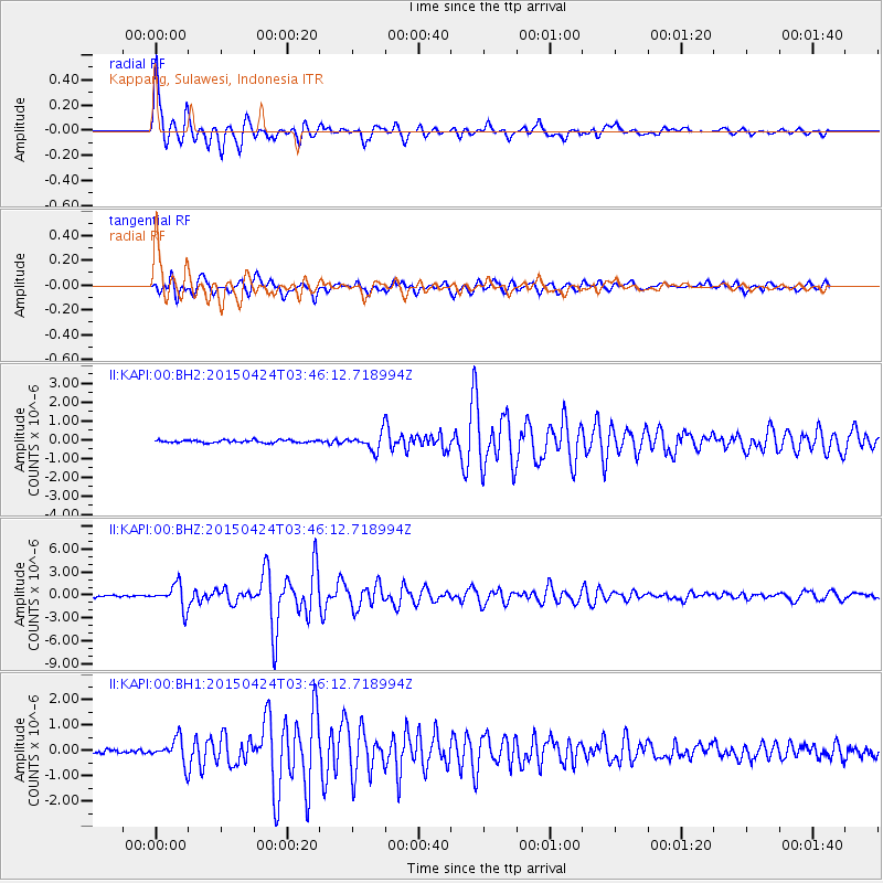
Signal To Noise
| Channel | StoN | STA | LTA |
| II:KAPI:00:BHZ:20150424T03:46:12.718994Z | 13.231738 | 1.5644381E-6 | 1.1823376E-7 |
| II:KAPI:00:BH1:20150424T03:46:12.718994Z | 7.6674623 | 4.7703617E-7 | 6.221565E-8 |
| II:KAPI:00:BH2:20150424T03:46:12.718994Z | 6.4283156 | 4.540195E-7 | 7.062806E-8 |
| Arrivals |
| Ps | 4.6 SECOND |
| PpPs | 14 SECOND |
| PsPs/PpSs | 18 SECOND |


