You are here: Home > Network List > IU - Global Seismograph Network (GSN - IRIS/USGS) Stations List
> Station CCM Cathedral Cave, Missouri, USA > Earthquake Result Viewer
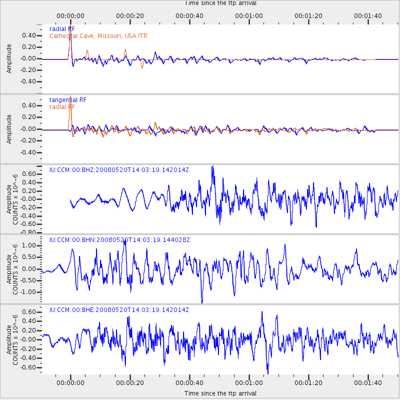
CCM Cathedral Cave, Missouri, USA - Earthquake Result Viewer
*The percent match for this event was below the threshold and hence no stack was calculated.
| Earthquake location: |
Rat Islands, Aleutian Islands |
| Earthquake latitude/longitude: |
51.2/178.8 |
| Earthquake time(UTC): |
2008/05/20 (141) 13:53:35 GMT |
| Earthquake Depth: |
27 km |
| Earthquake Magnitude: |
5.8 MB, 6.0 MS, 6.3 MW, 6.3 MW |
| Earthquake Catalog/Contributor: |
WHDF/NEIC |
|
| Network: |
IU Global Seismograph Network (GSN - IRIS/USGS) |
| Station: |
CCM Cathedral Cave, Missouri, USA |
| Lat/Lon: |
38.06 N/91.24 W |
| Elevation: |
222 m |
|
| Distance: |
61.5 deg |
| Az: |
63.914 deg |
| Baz: |
314.242 deg |
| Ray Param: |
$rayparam |
*The percent match for this event was below the threshold and hence was not used in the summary stack. |
|
| Radial Match: |
70.74183 % |
| Radial Bump: |
312 |
| Transverse Match: |
56.146923 % |
| Transverse Bump: |
400 |
| SOD ConfigId: |
2504 |
| Insert Time: |
2010-03-04 15:48:33.926 +0000 |
| GWidth: |
2.5 |
| Max Bumps: |
400 |
| Tol: |
0.001 |
|
Signal To Noise
| Channel | StoN | STA | LTA |
| IU:CCM:00:BHN:20080520T14:03:19.144028Z | 5.3025413 | 4.998292E-7 | 9.42622E-8 |
| IU:CCM:00:BHE:20080520T14:03:19.142014Z | 1.3666246 | 1.6339987E-7 | 1.1956458E-7 |
| IU:CCM:00:BHZ:20080520T14:03:19.142014Z | 1.3288875 | 1.5495921E-7 | 1.1660822E-7 |
| Arrivals |
| Ps | |
| PpPs | |
| PsPs/PpSs | |


