You are here: Home > Network List > AG - Arkansas Seismic Network Stations List
> Station LCAR Lake Charles,AR > Earthquake Result Viewer
LCAR Lake Charles,AR - Earthquake Result Viewer
| Earthquake location: |
Queen Charlotte Islands Region |
| Earthquake latitude/longitude: |
51.7/-130.8 |
| Earthquake time(UTC): |
2015/04/24 (114) 13:56:16 GMT |
| Earthquake Depth: |
10 km |
| Earthquake Magnitude: |
6.1 MO |
| Earthquake Catalog/Contributor: |
NEIC PDE/NEIC ALERT |
|
| Network: |
AG Arkansas Seismic Network |
| Station: |
LCAR Lake Charles,AR |
| Lat/Lon: |
36.07 N/91.15 W |
| Elevation: |
103 m |
|
| Distance: |
32.1 deg |
| Az: |
103.543 deg |
| Baz: |
311.74 deg |
| Ray Param: |
0.07880186 |
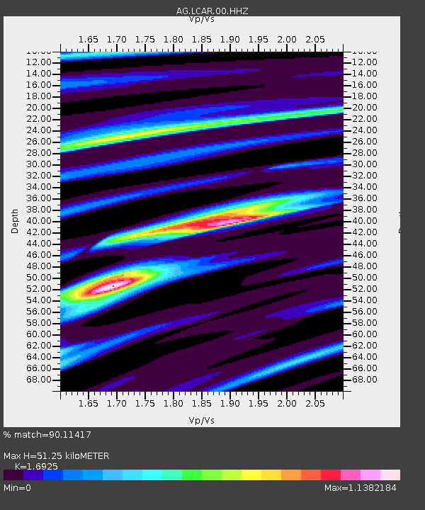
| Estimated Moho Depth: |
51.25 km |
| Estimated Crust Vp/Vs: |
1.69 |
| Assumed Crust Vp: |
6.53 km/s |
| Estimated Crust Vs: |
3.858 km/s |
| Estimated Crust Poisson's Ratio: |
0.23 |
|
| Radial Match: |
90.11417 % |
| Radial Bump: |
326 |
| Transverse Match: |
56.497982 % |
| Transverse Bump: |
400 |
| SOD ConfigId: |
872571 |
| Insert Time: |
2015-05-08 14:25:18.737 +0000 |
| GWidth: |
2.5 |
| Max Bumps: |
400 |
| Tol: |
0.001 |
|
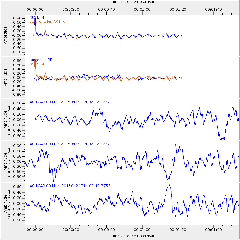
Signal To Noise
| Channel | StoN | STA | LTA |
| AG:LCAR:00:HHZ:20150424T14:02:12.375Z | 4.1856837 | 4.2525372E-7 | 1.01597195E-7 |
| AG:LCAR:00:HHN:20150424T14:02:12.375Z | 2.0285285 | 1.0998363E-7 | 5.4218436E-8 |
| AG:LCAR:00:HHE:20150424T14:02:12.375Z | 2.0610712 | 1.8585065E-7 | 9.017187E-8 |
| Arrivals |
| Ps | 5.9 SECOND |
| PpPs | 19 SECOND |
| PsPs/PpSs | 25 SECOND |


