You are here: Home > Network List > IU - Global Seismograph Network (GSN - IRIS/USGS) Stations List
> Station CCM Cathedral Cave, Missouri, USA > Earthquake Result Viewer
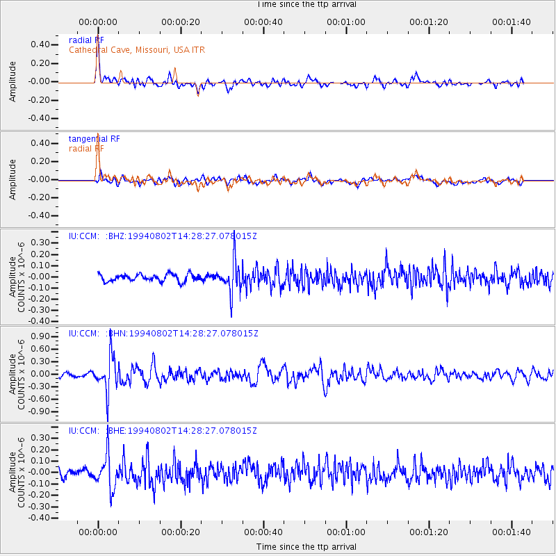
CCM Cathedral Cave, Missouri, USA - Earthquake Result Viewer
*The percent match for this event was below the threshold and hence no stack was calculated.
| Earthquake location: |
Near East Coast Of Kamchatka |
| Earthquake latitude/longitude: |
52.4/158.1 |
| Earthquake time(UTC): |
1994/08/02 (214) 14:17:54 GMT |
| Earthquake Depth: |
170 km |
| Earthquake Magnitude: |
5.8 MB, 5.9 UNKNOWN, 5.8 MW |
| Earthquake Catalog/Contributor: |
WHDF/NEIC |
|
| Network: |
IU Global Seismograph Network (GSN - IRIS/USGS) |
| Station: |
CCM Cathedral Cave, Missouri, USA |
| Lat/Lon: |
38.06 N/91.24 W |
| Elevation: |
222 m |
|
| Distance: |
71.7 deg |
| Az: |
51.095 deg |
| Baz: |
322.836 deg |
| Ray Param: |
$rayparam |
*The percent match for this event was below the threshold and hence was not used in the summary stack. |
|
| Radial Match: |
78.54392 % |
| Radial Bump: |
400 |
| Transverse Match: |
60.271675 % |
| Transverse Bump: |
400 |
| SOD ConfigId: |
4480 |
| Insert Time: |
2010-03-04 15:48:52.624 +0000 |
| GWidth: |
2.5 |
| Max Bumps: |
400 |
| Tol: |
0.001 |
|
Signal To Noise
| Channel | StoN | STA | LTA |
| IU:CCM: :BHN:19940802T14:28:27.078015Z | 7.1686387 | 4.3708118E-7 | 6.0971296E-8 |
| IU:CCM: :BHE:19940802T14:28:27.078015Z | 4.373426 | 1.5219297E-7 | 3.4799484E-8 |
| IU:CCM: :BHZ:19940802T14:28:27.078015Z | 4.56583 | 1.4440332E-7 | 3.1626957E-8 |
| Arrivals |
| Ps | |
| PpPs | |
| PsPs/PpSs | |


