You are here: Home > Network List > CI - Caltech Regional Seismic Network Stations List
> Station GLA Glamis, Glamis, CA, USA > Earthquake Result Viewer
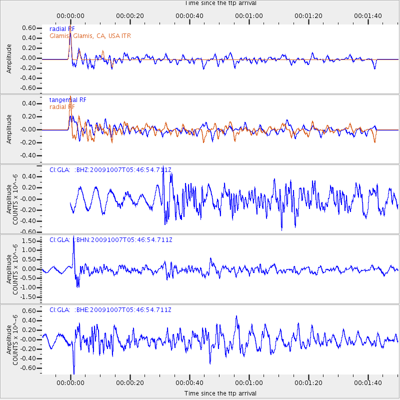
GLA Glamis, Glamis, CA, USA - Earthquake Result Viewer
*The percent match for this event was below the threshold and hence no stack was calculated.
| Earthquake location: |
Rat Islands, Aleutian Islands |
| Earthquake latitude/longitude: |
52.2/178.1 |
| Earthquake time(UTC): |
2009/10/07 (280) 05:38:37 GMT |
| Earthquake Depth: |
138 km |
| Earthquake Magnitude: |
5.6 MB, 5.6 MW, 5.6 MW |
| Earthquake Catalog/Contributor: |
WHDF/NEIC |
|
| Network: |
CI Caltech Regional Seismic Network |
| Station: |
GLA Glamis, Glamis, CA, USA |
| Lat/Lon: |
33.05 N/114.83 W |
| Elevation: |
610 m |
|
| Distance: |
51.0 deg |
| Az: |
84.301 deg |
| Baz: |
313.12 deg |
| Ray Param: |
$rayparam |
*The percent match for this event was below the threshold and hence was not used in the summary stack. |
|
| Radial Match: |
63.975433 % |
| Radial Bump: |
400 |
| Transverse Match: |
57.20065 % |
| Transverse Bump: |
400 |
| SOD ConfigId: |
2622 |
| Insert Time: |
2010-02-25 23:37:39.403 +0000 |
| GWidth: |
2.5 |
| Max Bumps: |
400 |
| Tol: |
0.001 |
|
Signal To Noise
| Channel | StoN | STA | LTA |
| CI:GLA: :BHN:20091007T05:46:54.711Z | 5.065011 | 5.569052E-7 | 1.0995143E-7 |
| CI:GLA: :BHE:20091007T05:46:54.711Z | 2.3935065 | 2.2038945E-7 | 9.207807E-8 |
| CI:GLA: :BHZ:20091007T05:46:54.711Z | 2.2609754 | 2.8354967E-7 | 1.2541034E-7 |
| Arrivals |
| Ps | |
| PpPs | |
| PsPs/PpSs | |


