You are here: Home > Network List > IU - Global Seismograph Network (GSN - IRIS/USGS) Stations List
> Station CCM Cathedral Cave, Missouri, USA > Earthquake Result Viewer
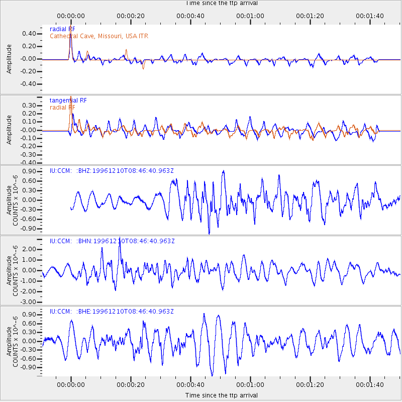
CCM Cathedral Cave, Missouri, USA - Earthquake Result Viewer
*The percent match for this event was below the threshold and hence no stack was calculated.
| Earthquake location: |
Central Mid-Atlantic Ridge |
| Earthquake latitude/longitude: |
0.9/-30.0 |
| Earthquake time(UTC): |
1996/12/10 (345) 08:36:18 GMT |
| Earthquake Depth: |
10 km |
| Earthquake Magnitude: |
6.0 MB, 6.2 MS, 6.6 UNKNOWN, 6.6 MW |
| Earthquake Catalog/Contributor: |
WHDF/NEIC |
|
| Network: |
IU Global Seismograph Network (GSN - IRIS/USGS) |
| Station: |
CCM Cathedral Cave, Missouri, USA |
| Lat/Lon: |
38.06 N/91.24 W |
| Elevation: |
222 m |
|
| Distance: |
67.1 deg |
| Az: |
311.313 deg |
| Baz: |
107.942 deg |
| Ray Param: |
$rayparam |
*The percent match for this event was below the threshold and hence was not used in the summary stack. |
|
| Radial Match: |
56.62792 % |
| Radial Bump: |
305 |
| Transverse Match: |
62.42954 % |
| Transverse Bump: |
400 |
| SOD ConfigId: |
4480 |
| Insert Time: |
2010-03-04 15:49:19.313 +0000 |
| GWidth: |
2.5 |
| Max Bumps: |
400 |
| Tol: |
0.001 |
|
Signal To Noise
| Channel | StoN | STA | LTA |
| IU:CCM: :BHN:19961210T08:46:40.963Z | 1.2156159 | 4.9055524E-7 | 4.035446E-7 |
| IU:CCM: :BHE:19961210T08:46:40.963Z | 1.1027931 | 4.2202583E-7 | 3.8268814E-7 |
| IU:CCM: :BHZ:19961210T08:46:40.963Z | 2.5246646 | 3.960161E-7 | 1.568589E-7 |
| Arrivals |
| Ps | |
| PpPs | |
| PsPs/PpSs | |


