You are here: Home > Network List > IU - Global Seismograph Network (GSN - IRIS/USGS) Stations List
> Station CCM Cathedral Cave, Missouri, USA > Earthquake Result Viewer
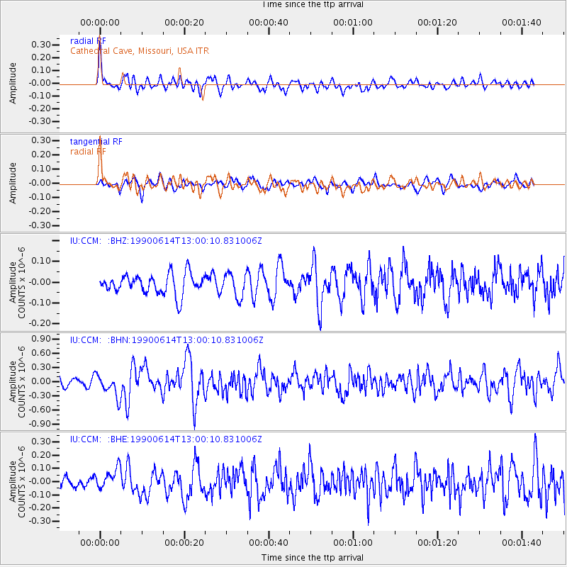
CCM Cathedral Cave, Missouri, USA - Earthquake Result Viewer
*The percent match for this event was below the threshold and hence no stack was calculated.
| Earthquake location: |
Kazakhstan-Xinjiang Border Reg. |
| Earthquake latitude/longitude: |
47.9/85.1 |
| Earthquake time(UTC): |
1990/06/14 (165) 12:47:28 GMT |
| Earthquake Depth: |
54 km |
| Earthquake Magnitude: |
6.2 MB, 6.8 MS |
| Earthquake Catalog/Contributor: |
WHDF/NEIC |
|
| Network: |
IU Global Seismograph Network (GSN - IRIS/USGS) |
| Station: |
CCM Cathedral Cave, Missouri, USA |
| Lat/Lon: |
38.06 N/91.24 W |
| Elevation: |
222 m |
|
| Distance: |
94.4 deg |
| Az: |
357.123 deg |
| Baz: |
2.453 deg |
| Ray Param: |
$rayparam |
*The percent match for this event was below the threshold and hence was not used in the summary stack. |
|
| Radial Match: |
75.1393 % |
| Radial Bump: |
400 |
| Transverse Match: |
59.062504 % |
| Transverse Bump: |
400 |
| SOD ConfigId: |
4480 |
| Insert Time: |
2010-03-04 15:49:21.643 +0000 |
| GWidth: |
2.5 |
| Max Bumps: |
400 |
| Tol: |
0.001 |
|
Signal To Noise
| Channel | StoN | STA | LTA |
| IU:CCM: :BHN:19900614T13:00:10.831006Z | 2.9307485 | 2.42359E-7 | 8.269526E-8 |
| IU:CCM: :BHE:19900614T13:00:10.831006Z | 1.573934 | 9.0678704E-8 | 5.7612777E-8 |
| IU:CCM: :BHZ:19900614T13:00:10.831006Z | 1.2238227 | 5.883377E-8 | 4.807377E-8 |
| Arrivals |
| Ps | |
| PpPs | |
| PsPs/PpSs | |


