You are here: Home > Network List > IU - Global Seismograph Network (GSN - IRIS/USGS) Stations List
> Station CCM Cathedral Cave, Missouri, USA > Earthquake Result Viewer
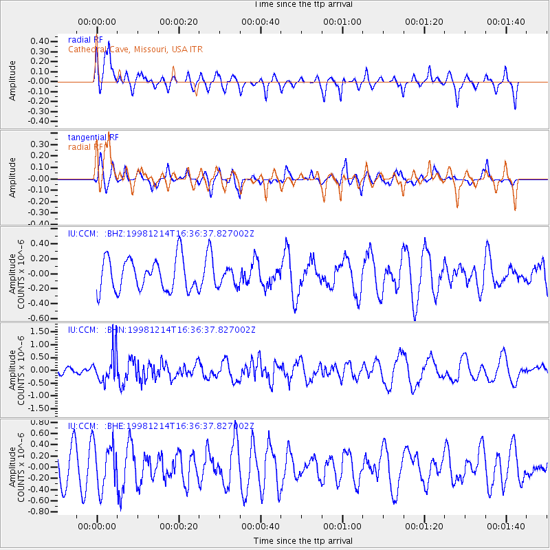
CCM Cathedral Cave, Missouri, USA - Earthquake Result Viewer
*The percent match for this event was below the threshold and hence no stack was calculated.
| Earthquake location: |
S. Chile-Argentina Border Region |
| Earthquake latitude/longitude: |
-38.2/-71.0 |
| Earthquake time(UTC): |
1998/12/14 (348) 16:25:24 GMT |
| Earthquake Depth: |
138 km |
| Earthquake Magnitude: |
6.0 UNKNOWN, 4.8 MS, 5.4 MB |
| Earthquake Catalog/Contributor: |
WHDF/NEIC |
|
| Network: |
IU Global Seismograph Network (GSN - IRIS/USGS) |
| Station: |
CCM Cathedral Cave, Missouri, USA |
| Lat/Lon: |
38.06 N/91.24 W |
| Elevation: |
222 m |
|
| Distance: |
78.1 deg |
| Az: |
343.819 deg |
| Baz: |
163.855 deg |
| Ray Param: |
$rayparam |
*The percent match for this event was below the threshold and hence was not used in the summary stack. |
|
| Radial Match: |
58.646725 % |
| Radial Bump: |
400 |
| Transverse Match: |
46.83112 % |
| Transverse Bump: |
367 |
| SOD ConfigId: |
4480 |
| Insert Time: |
2010-03-04 15:49:27.025 +0000 |
| GWidth: |
2.5 |
| Max Bumps: |
400 |
| Tol: |
0.001 |
|
Signal To Noise
| Channel | StoN | STA | LTA |
| IU:CCM: :BHN:19981214T16:36:37.827002Z | 3.1610124 | 6.1982206E-7 | 1.9608339E-7 |
| IU:CCM: :BHE:19981214T16:36:37.827002Z | 1.4627317 | 3.9346256E-7 | 2.689916E-7 |
| IU:CCM: :BHZ:19981214T16:36:37.827002Z | 0.55312204 | 1.1874364E-7 | 2.1467892E-7 |
| Arrivals |
| Ps | |
| PpPs | |
| PsPs/PpSs | |


