You are here: Home > Network List > IU - Global Seismograph Network (GSN - IRIS/USGS) Stations List
> Station CCM Cathedral Cave, Missouri, USA > Earthquake Result Viewer
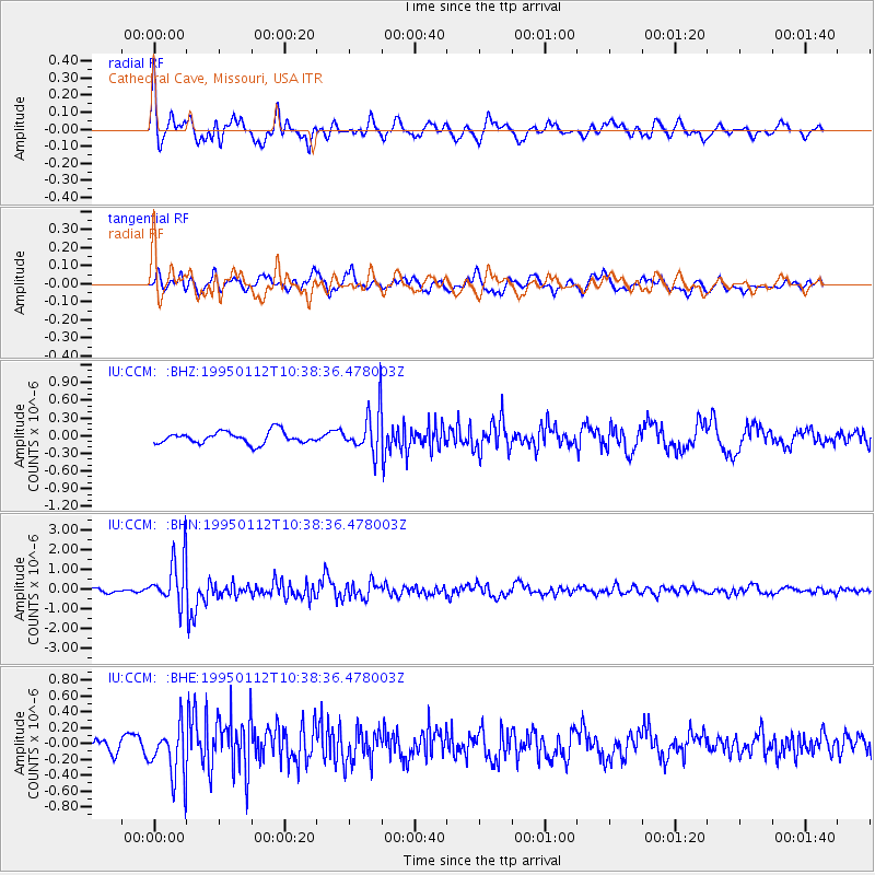
CCM Cathedral Cave, Missouri, USA - Earthquake Result Viewer
*The percent match for this event was below the threshold and hence no stack was calculated.
| Earthquake location: |
Kuril Islands |
| Earthquake latitude/longitude: |
44.0/147.1 |
| Earthquake time(UTC): |
1995/01/12 (012) 10:26:46 GMT |
| Earthquake Depth: |
33 km |
| Earthquake Magnitude: |
6.2 MB, 5.4 MS, 6.1 UNKNOWN, 6.0 MW |
| Earthquake Catalog/Contributor: |
WHDF/NEIC |
|
| Network: |
IU Global Seismograph Network (GSN - IRIS/USGS) |
| Station: |
CCM Cathedral Cave, Missouri, USA |
| Lat/Lon: |
38.06 N/91.24 W |
| Elevation: |
222 m |
|
| Distance: |
82.8 deg |
| Az: |
42.629 deg |
| Baz: |
321.737 deg |
| Ray Param: |
$rayparam |
*The percent match for this event was below the threshold and hence was not used in the summary stack. |
|
| Radial Match: |
78.94731 % |
| Radial Bump: |
400 |
| Transverse Match: |
63.270866 % |
| Transverse Bump: |
400 |
| SOD ConfigId: |
4480 |
| Insert Time: |
2010-03-04 15:49:27.521 +0000 |
| GWidth: |
2.5 |
| Max Bumps: |
400 |
| Tol: |
0.001 |
|
Signal To Noise
| Channel | StoN | STA | LTA |
| IU:CCM: :BHN:19950112T10:38:36.478003Z | 9.103739 | 1.2018422E-6 | 1.3201634E-7 |
| IU:CCM: :BHE:19950112T10:38:36.478003Z | 3.492764 | 3.3297658E-7 | 9.5333256E-8 |
| IU:CCM: :BHZ:19950112T10:38:36.478003Z | 3.6035147 | 3.645618E-7 | 1.01168396E-7 |
| Arrivals |
| Ps | |
| PpPs | |
| PsPs/PpSs | |


