You are here: Home > Network List > IU - Global Seismograph Network (GSN - IRIS/USGS) Stations List
> Station CCM Cathedral Cave, Missouri, USA > Earthquake Result Viewer
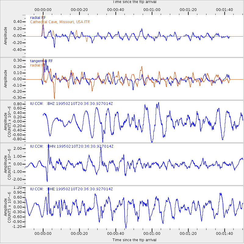
CCM Cathedral Cave, Missouri, USA - Earthquake Result Viewer
*The percent match for this event was below the threshold and hence no stack was calculated.
| Earthquake location: |
Chile-Bolivia Border Region |
| Earthquake latitude/longitude: |
-19.8/-68.5 |
| Earthquake time(UTC): |
1995/02/10 (041) 20:27:03 GMT |
| Earthquake Depth: |
164 km |
| Earthquake Magnitude: |
5.7 UNKNOWN, 5.4 MB, 5.7 MW |
| Earthquake Catalog/Contributor: |
WHDF/NEIC |
|
| Network: |
IU Global Seismograph Network (GSN - IRIS/USGS) |
| Station: |
CCM Cathedral Cave, Missouri, USA |
| Lat/Lon: |
38.06 N/91.24 W |
| Elevation: |
222 m |
|
| Distance: |
61.3 deg |
| Az: |
339.687 deg |
| Baz: |
155.534 deg |
| Ray Param: |
$rayparam |
*The percent match for this event was below the threshold and hence was not used in the summary stack. |
|
| Radial Match: |
47.88733 % |
| Radial Bump: |
390 |
| Transverse Match: |
65.9793 % |
| Transverse Bump: |
400 |
| SOD ConfigId: |
4480 |
| Insert Time: |
2010-03-04 15:49:34.468 +0000 |
| GWidth: |
2.5 |
| Max Bumps: |
400 |
| Tol: |
0.001 |
|
Signal To Noise
| Channel | StoN | STA | LTA |
| IU:CCM: :BHN:19950210T20:36:30.927014Z | 3.0505638 | 9.482173E-7 | 3.1083346E-7 |
| IU:CCM: :BHE:19950210T20:36:30.927014Z | 1.3772396 | 4.859734E-7 | 3.5286044E-7 |
| IU:CCM: :BHZ:19950210T20:36:30.927014Z | 1.7379607 | 4.6337914E-7 | 2.6662235E-7 |
| Arrivals |
| Ps | |
| PpPs | |
| PsPs/PpSs | |


