You are here: Home > Network List > IU - Global Seismograph Network (GSN - IRIS/USGS) Stations List
> Station CCM Cathedral Cave, Missouri, USA > Earthquake Result Viewer
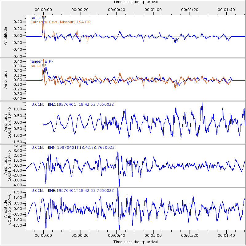
CCM Cathedral Cave, Missouri, USA - Earthquake Result Viewer
*The percent match for this event was below the threshold and hence no stack was calculated.
| Earthquake location: |
Northern Chile |
| Earthquake latitude/longitude: |
-18.3/-69.5 |
| Earthquake time(UTC): |
1997/04/01 (091) 18:33:32 GMT |
| Earthquake Depth: |
114 km |
| Earthquake Magnitude: |
5.9 MB, 6.2 UNKNOWN, 6.1 MW |
| Earthquake Catalog/Contributor: |
WHDF/NEIC |
|
| Network: |
IU Global Seismograph Network (GSN - IRIS/USGS) |
| Station: |
CCM Cathedral Cave, Missouri, USA |
| Lat/Lon: |
38.06 N/91.24 W |
| Elevation: |
222 m |
|
| Distance: |
59.7 deg |
| Az: |
340.215 deg |
| Baz: |
155.96 deg |
| Ray Param: |
$rayparam |
*The percent match for this event was below the threshold and hence was not used in the summary stack. |
|
| Radial Match: |
70.02629 % |
| Radial Bump: |
400 |
| Transverse Match: |
70.9184 % |
| Transverse Bump: |
400 |
| SOD ConfigId: |
4480 |
| Insert Time: |
2010-03-04 15:49:36.938 +0000 |
| GWidth: |
2.5 |
| Max Bumps: |
400 |
| Tol: |
0.001 |
|
Signal To Noise
| Channel | StoN | STA | LTA |
| IU:CCM: :BHN:19970401T18:42:53.765002Z | 3.0398967 | 1.3816467E-6 | 4.545045E-7 |
| IU:CCM: :BHE:19970401T18:42:53.765002Z | 1.524288 | 7.663707E-7 | 5.027729E-7 |
| IU:CCM: :BHZ:19970401T18:42:53.765002Z | 0.9294043 | 3.3183372E-7 | 3.5703914E-7 |
| Arrivals |
| Ps | |
| PpPs | |
| PsPs/PpSs | |


