You are here: Home > Network List > IU - Global Seismograph Network (GSN - IRIS/USGS) Stations List
> Station CCM Cathedral Cave, Missouri, USA > Earthquake Result Viewer
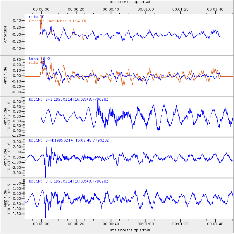
CCM Cathedral Cave, Missouri, USA - Earthquake Result Viewer
*The percent match for this event was below the threshold and hence no stack was calculated.
| Earthquake location: |
Chile-Argentina Border Region |
| Earthquake latitude/longitude: |
-23.3/-67.7 |
| Earthquake time(UTC): |
1995/02/14 (045) 15:53:56 GMT |
| Earthquake Depth: |
156 km |
| Earthquake Magnitude: |
5.7 MB, 6.0 UNKNOWN, 6.0 MW |
| Earthquake Catalog/Contributor: |
WHDF/NEIC |
|
| Network: |
IU Global Seismograph Network (GSN - IRIS/USGS) |
| Station: |
CCM Cathedral Cave, Missouri, USA |
| Lat/Lon: |
38.06 N/91.24 W |
| Elevation: |
222 m |
|
| Distance: |
64.9 deg |
| Az: |
339.624 deg |
| Baz: |
156.075 deg |
| Ray Param: |
$rayparam |
*The percent match for this event was below the threshold and hence was not used in the summary stack. |
|
| Radial Match: |
55.1164 % |
| Radial Bump: |
400 |
| Transverse Match: |
72.85438 % |
| Transverse Bump: |
373 |
| SOD ConfigId: |
4480 |
| Insert Time: |
2010-03-04 15:49:39.049 +0000 |
| GWidth: |
2.5 |
| Max Bumps: |
400 |
| Tol: |
0.001 |
|
Signal To Noise
| Channel | StoN | STA | LTA |
| IU:CCM: :BHN:19950214T16:03:48.779028Z | 4.2984986 | 1.0070289E-6 | 2.3427455E-7 |
| IU:CCM: :BHE:19950214T16:03:48.779028Z | 2.9586444 | 6.5271723E-7 | 2.2061361E-7 |
| IU:CCM: :BHZ:19950214T16:03:48.779028Z | 2.083065 | 4.7246814E-7 | 2.2681392E-7 |
| Arrivals |
| Ps | |
| PpPs | |
| PsPs/PpSs | |


