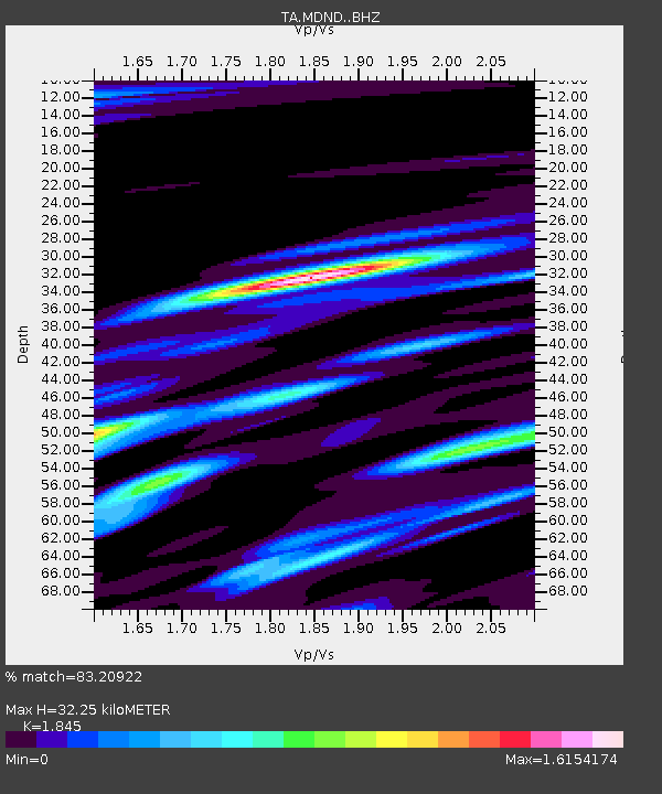
MDND Maddock, ND, USA - Earthquake Result Viewer
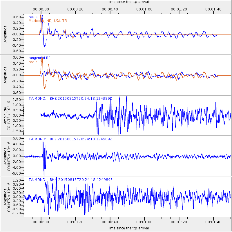
Earthquake location: Andreanof Islands, Aleutian Is.
Earthquake latitude/longitude: 51.7/-175.2
Earthquake time(UTC): 2015/08/15 (227) 20:16:21 GMT
Earthquake Depth: 32 km
Earthquake Magnitude: 5.6 MWB, 5.5 MI, 5.6 ML, 5.6 MWC
Earthquake Catalog/Contributor: NEIC PDE/NEIC COMCAT
Network: TA USArray Transportable Network (new EarthScope stations)
Station: MDND Maddock, ND, USA
Lat/Lon: 47.85 N/99.60 W
Elevation: 479 m
Distance: 46.9 deg
Az: 63.248 deg
Baz: 304.353 deg
Ray Param: 0.07026705
Estimated Moho Depth: 32.25 km
Estimated Crust Vp/Vs: 1.85
Assumed Crust Vp: 6.53 km/s
Estimated Crust Vs: 3.54 km/s
Estimated Crust Poisson's Ratio: 0.29
Radial Match: 83.20922 %
Radial Bump: 400
Transverse Match: 62.124653 %
Transverse Bump: 400
SOD ConfigId: 7422571
Insert Time: 2019-04-20 11:32:37.095 +0000
GWidth: 2.5
Max Bumps: 400
Tol: 0.001

Signal To Noise

ChannelStoNSTALTA
TA:MDND: :BHZ:20150815T20:24:18.124989Z19.8776452.2784204E-61.14622246E-7
TA:MDND: :BHN:20150815T20:24:18.124989Z3.10670045.8044805E-71.8683747E-7
TA:MDND: :BHE:20150815T20:24:18.124989Z4.59881456.7877386E-71.4759758E-7
Arrivals
Ps4.4 SECOND
PpPs13 SECOND
PsPs/PpSs18 SECOND