You are here: Home > Network List > IU - Global Seismograph Network (GSN - IRIS/USGS) Stations List
> Station CCM Cathedral Cave, Missouri, USA > Earthquake Result Viewer
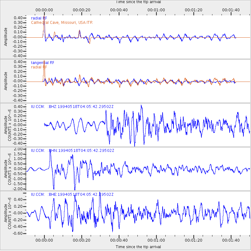
CCM Cathedral Cave, Missouri, USA - Earthquake Result Viewer
*The percent match for this event was below the threshold and hence no stack was calculated.
| Earthquake location: |
Kuril Islands |
| Earthquake latitude/longitude: |
44.7/149.4 |
| Earthquake time(UTC): |
1994/05/18 (138) 03:54:02 GMT |
| Earthquake Depth: |
46 km |
| Earthquake Magnitude: |
5.8 MB, 5.8 MS, 5.5 UNKNOWN, 6.2 MW |
| Earthquake Catalog/Contributor: |
WHDF/NEIC |
|
| Network: |
IU Global Seismograph Network (GSN - IRIS/USGS) |
| Station: |
CCM Cathedral Cave, Missouri, USA |
| Lat/Lon: |
38.06 N/91.24 W |
| Elevation: |
222 m |
|
| Distance: |
81.1 deg |
| Az: |
44.167 deg |
| Baz: |
320.975 deg |
| Ray Param: |
$rayparam |
*The percent match for this event was below the threshold and hence was not used in the summary stack. |
|
| Radial Match: |
73.42064 % |
| Radial Bump: |
400 |
| Transverse Match: |
56.688366 % |
| Transverse Bump: |
400 |
| SOD ConfigId: |
4480 |
| Insert Time: |
2010-03-04 15:49:58.122 +0000 |
| GWidth: |
2.5 |
| Max Bumps: |
400 |
| Tol: |
0.001 |
|
Signal To Noise
| Channel | StoN | STA | LTA |
| IU:CCM: :BHN:19940518T04:05:42.29502Z | 6.2003427 | 6.9712644E-7 | 1.1243353E-7 |
| IU:CCM: :BHE:19940518T04:05:42.29502Z | 1.6877075 | 1.8254082E-7 | 1.08159036E-7 |
| IU:CCM: :BHZ:19940518T04:05:42.29502Z | 1.8087666 | 1.3877857E-7 | 7.672553E-8 |
| Arrivals |
| Ps | |
| PpPs | |
| PsPs/PpSs | |


