You are here: Home > Network List > IU - Global Seismograph Network (GSN - IRIS/USGS) Stations List
> Station CCM Cathedral Cave, Missouri, USA > Earthquake Result Viewer
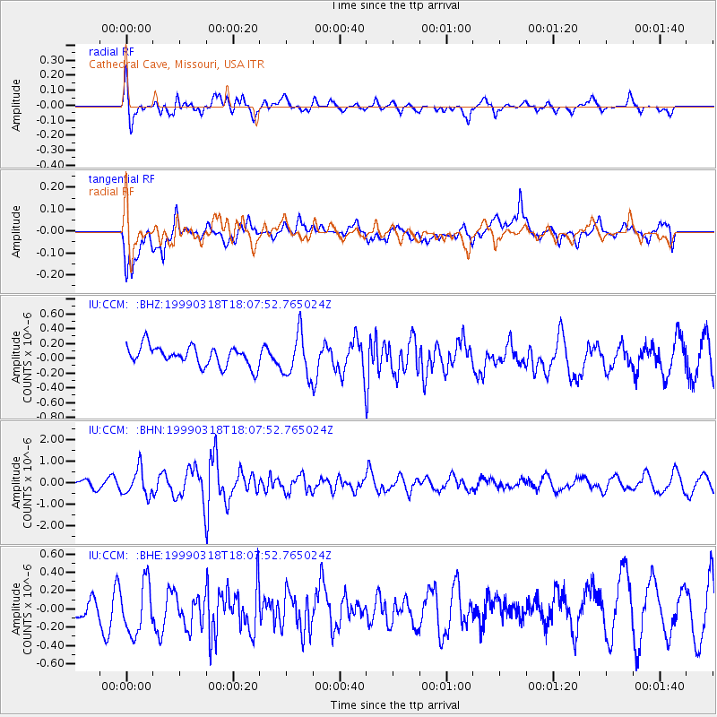
CCM Cathedral Cave, Missouri, USA - Earthquake Result Viewer
*The percent match for this event was below the threshold and hence no stack was calculated.
| Earthquake location: |
Hokkaido, Japan Region |
| Earthquake latitude/longitude: |
41.1/143.0 |
| Earthquake time(UTC): |
1999/03/18 (077) 17:55:43 GMT |
| Earthquake Depth: |
41 km |
| Earthquake Magnitude: |
5.9 MB, 5.6 MS, 6.1 MW, 6.0 MW |
| Earthquake Catalog/Contributor: |
WHDF/NEIC |
|
| Network: |
IU Global Seismograph Network (GSN - IRIS/USGS) |
| Station: |
CCM Cathedral Cave, Missouri, USA |
| Lat/Lon: |
38.06 N/91.24 W |
| Elevation: |
222 m |
|
| Distance: |
87.0 deg |
| Az: |
39.889 deg |
| Baz: |
322.123 deg |
| Ray Param: |
$rayparam |
*The percent match for this event was below the threshold and hence was not used in the summary stack. |
|
| Radial Match: |
72.265236 % |
| Radial Bump: |
400 |
| Transverse Match: |
63.521698 % |
| Transverse Bump: |
400 |
| SOD ConfigId: |
4480 |
| Insert Time: |
2010-03-04 15:49:59.392 +0000 |
| GWidth: |
2.5 |
| Max Bumps: |
400 |
| Tol: |
0.001 |
|
Signal To Noise
| Channel | StoN | STA | LTA |
| IU:CCM: :BHN:19990318T18:07:52.765024Z | 2.708746 | 6.184054E-7 | 2.2829953E-7 |
| IU:CCM: :BHE:19990318T18:07:52.765024Z | 1.9600806 | 2.9805244E-7 | 1.5206132E-7 |
| IU:CCM: :BHZ:19990318T18:07:52.765024Z | 2.1961377 | 2.913675E-7 | 1.3267271E-7 |
| Arrivals |
| Ps | |
| PpPs | |
| PsPs/PpSs | |


