You are here: Home > Network List > NM - Cooperative New Madrid Seismic Network Stations List
> Station CLTN Cedars of Lebanon,TN > Earthquake Result Viewer
CLTN Cedars of Lebanon,TN - Earthquake Result Viewer
| Earthquake location: |
Queen Charlotte Islands Region |
| Earthquake latitude/longitude: |
51.7/-130.8 |
| Earthquake time(UTC): |
2015/04/24 (114) 13:56:16 GMT |
| Earthquake Depth: |
10 km |
| Earthquake Magnitude: |
6.1 MO |
| Earthquake Catalog/Contributor: |
NEIC PDE/NEIC ALERT |
|
| Network: |
NM Cooperative New Madrid Seismic Network |
| Station: |
CLTN Cedars of Lebanon,TN |
| Lat/Lon: |
36.09 N/86.33 W |
| Elevation: |
208 m |
|
| Distance: |
35.0 deg |
| Az: |
98.858 deg |
| Baz: |
310.662 deg |
| Ray Param: |
0.077444755 |
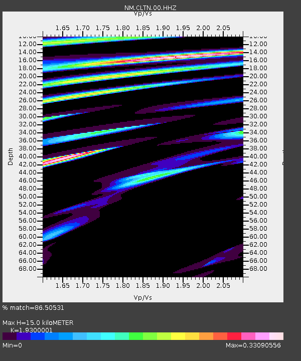
| Estimated Moho Depth: |
15.0 km |
| Estimated Crust Vp/Vs: |
1.93 |
| Assumed Crust Vp: |
6.444 km/s |
| Estimated Crust Vs: |
3.339 km/s |
| Estimated Crust Poisson's Ratio: |
0.32 |
|
| Radial Match: |
86.50531 % |
| Radial Bump: |
400 |
| Transverse Match: |
58.84846 % |
| Transverse Bump: |
400 |
| SOD ConfigId: |
872571 |
| Insert Time: |
2015-05-08 14:28:54.130 +0000 |
| GWidth: |
2.5 |
| Max Bumps: |
400 |
| Tol: |
0.001 |
|

Signal To Noise
| Channel | StoN | STA | LTA |
| NM:CLTN:00:HHZ:20150424T14:02:37.795013Z | 2.8976924 | 3.5069777E-7 | 1.2102656E-7 |
| NM:CLTN:00:HHN:20150424T14:02:37.795013Z | 1.7399722 | 2.0630326E-7 | 1.1856698E-7 |
| NM:CLTN:00:HHE:20150424T14:02:37.795013Z | 1.8592092 | 2.2971881E-7 | 1.2355727E-7 |
| Arrivals |
| Ps | 2.3 SECOND |
| PpPs | 6.4 SECOND |
| PsPs/PpSs | 8.7 SECOND |


