You are here: Home > Network List > CN - Canadian National Seismograph Network Stations List
> Station INK INUVIK, NT > Earthquake Result Viewer
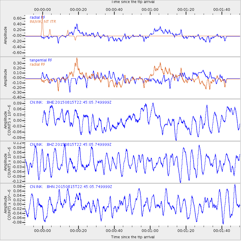
INK INUVIK, NT - Earthquake Result Viewer
*The percent match for this event was below the threshold and hence no stack was calculated.
| Earthquake location: |
Kuril Islands |
| Earthquake latitude/longitude: |
45.9/150.8 |
| Earthquake time(UTC): |
2015/08/15 (227) 22:37:45 GMT |
| Earthquake Depth: |
100 km |
| Earthquake Magnitude: |
4.3 mb |
| Earthquake Catalog/Contributor: |
ISC/ISC |
|
| Network: |
CN Canadian National Seismograph Network |
| Station: |
INK INUVIK, NT |
| Lat/Lon: |
68.31 N/133.53 W |
| Elevation: |
44 m |
|
| Distance: |
43.2 deg |
| Az: |
31.754 deg |
| Baz: |
278.874 deg |
| Ray Param: |
$rayparam |
*The percent match for this event was below the threshold and hence was not used in the summary stack. |
|
| Radial Match: |
46.411644 % |
| Radial Bump: |
400 |
| Transverse Match: |
43.151062 % |
| Transverse Bump: |
400 |
| SOD ConfigId: |
7422571 |
| Insert Time: |
2019-04-20 11:39:36.301 +0000 |
| GWidth: |
2.5 |
| Max Bumps: |
400 |
| Tol: |
0.001 |
|
Signal To Noise
| Channel | StoN | STA | LTA |
| CN:INK: :BHZ:20150815T22:45:05.749999Z | 1.15959 | 4.946363E-8 | 4.265614E-8 |
| CN:INK: :BHN:20150815T22:45:05.749999Z | 1.2542001 | 4.335727E-8 | 3.456966E-8 |
| CN:INK: :BHE:20150815T22:45:05.749999Z | 1.533727 | 5.1150852E-8 | 3.3350688E-8 |
| Arrivals |
| Ps | |
| PpPs | |
| PsPs/PpSs | |


