You are here: Home > Network List > IU - Global Seismograph Network (GSN - IRIS/USGS) Stations List
> Station CCM Cathedral Cave, Missouri, USA > Earthquake Result Viewer
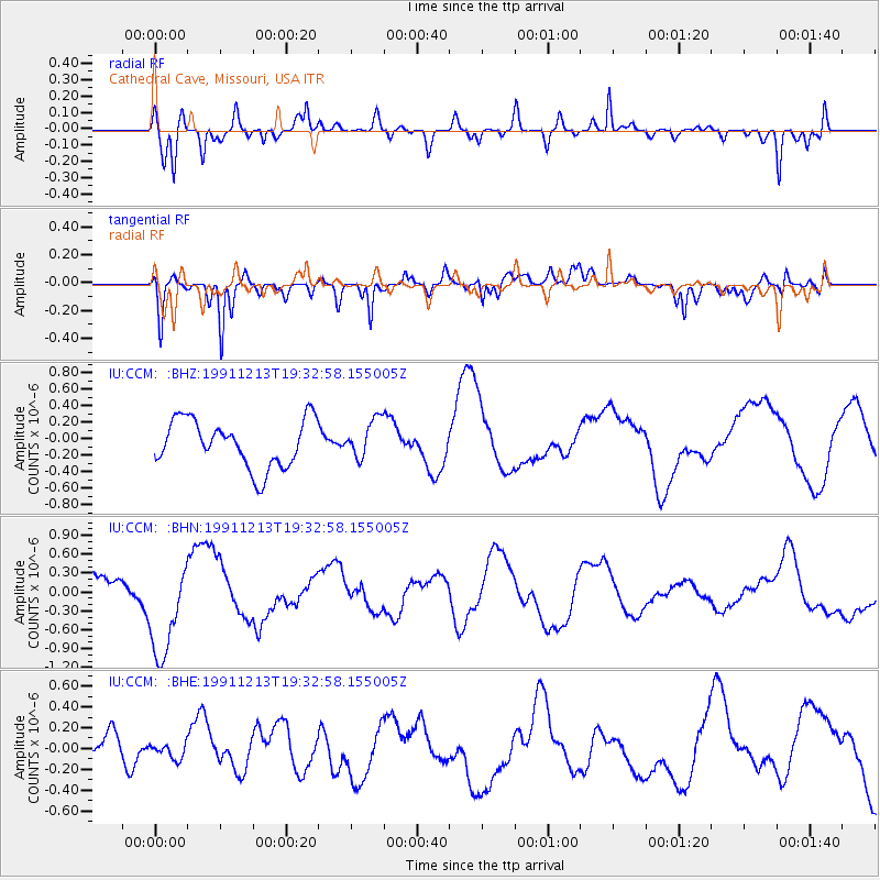
CCM Cathedral Cave, Missouri, USA - Earthquake Result Viewer
*The percent match for this event was below the threshold and hence no stack was calculated.
| Earthquake location: |
Kuril Islands |
| Earthquake latitude/longitude: |
45.2/151.6 |
| Earthquake time(UTC): |
1991/12/13 (347) 19:21:26 GMT |
| Earthquake Depth: |
45 km |
| Earthquake Magnitude: |
5.5 MS, 5.4 MB |
| Earthquake Catalog/Contributor: |
WHDF/NEIC |
|
| Network: |
IU Global Seismograph Network (GSN - IRIS/USGS) |
| Station: |
CCM Cathedral Cave, Missouri, USA |
| Lat/Lon: |
38.06 N/91.24 W |
| Elevation: |
222 m |
|
| Distance: |
79.7 deg |
| Az: |
45.571 deg |
| Baz: |
320.23 deg |
| Ray Param: |
$rayparam |
*The percent match for this event was below the threshold and hence was not used in the summary stack. |
|
| Radial Match: |
81.923 % |
| Radial Bump: |
338 |
| Transverse Match: |
56.804386 % |
| Transverse Bump: |
388 |
| SOD ConfigId: |
4480 |
| Insert Time: |
2010-03-04 15:50:21.209 +0000 |
| GWidth: |
2.5 |
| Max Bumps: |
400 |
| Tol: |
0.001 |
|
Signal To Noise
| Channel | StoN | STA | LTA |
| IU:CCM: :BHN:19911213T19:32:58.155005Z | 3.1559367 | 7.898795E-7 | 2.502837E-7 |
| IU:CCM: :BHE:19911213T19:32:58.155005Z | 0.2564305 | 6.8718585E-8 | 2.679813E-7 |
| IU:CCM: :BHZ:19911213T19:32:58.155005Z | 0.8108985 | 2.3240523E-7 | 2.866021E-7 |
| Arrivals |
| Ps | |
| PpPs | |
| PsPs/PpSs | |


