You are here: Home > Network List > TA - USArray Transportable Network (new EarthScope stations) Stations List
> Station M53A WI Miller and Sons, Farmdale, OH, USA > Earthquake Result Viewer
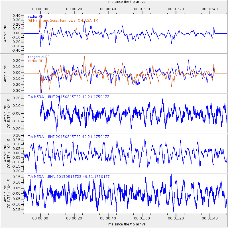
M53A WI Miller and Sons, Farmdale, OH, USA - Earthquake Result Viewer
*The percent match for this event was below the threshold and hence no stack was calculated.
| Earthquake location: |
Kuril Islands |
| Earthquake latitude/longitude: |
45.9/150.8 |
| Earthquake time(UTC): |
2015/08/15 (227) 22:37:45 GMT |
| Earthquake Depth: |
100 km |
| Earthquake Magnitude: |
4.3 mb |
| Earthquake Catalog/Contributor: |
ISC/ISC |
|
| Network: |
TA USArray Transportable Network (new EarthScope stations) |
| Station: |
M53A WI Miller and Sons, Farmdale, OH, USA |
| Lat/Lon: |
41.44 N/80.68 W |
| Elevation: |
334 m |
|
| Distance: |
81.6 deg |
| Az: |
36.498 deg |
| Baz: |
326.483 deg |
| Ray Param: |
$rayparam |
*The percent match for this event was below the threshold and hence was not used in the summary stack. |
|
| Radial Match: |
46.99787 % |
| Radial Bump: |
400 |
| Transverse Match: |
54.93243 % |
| Transverse Bump: |
400 |
| SOD ConfigId: |
7422571 |
| Insert Time: |
2019-04-20 11:44:25.015 +0000 |
| GWidth: |
2.5 |
| Max Bumps: |
400 |
| Tol: |
0.001 |
|
Signal To Noise
| Channel | StoN | STA | LTA |
| TA:M53A: :BHZ:20150815T22:49:21.175017Z | 1.3625406 | 7.249413E-8 | 5.320512E-8 |
| TA:M53A: :BHN:20150815T22:49:21.175017Z | 1.2212985 | 8.0846036E-8 | 6.619679E-8 |
| TA:M53A: :BHE:20150815T22:49:21.175017Z | 0.69767517 | 5.253232E-8 | 7.529624E-8 |
| Arrivals |
| Ps | |
| PpPs | |
| PsPs/PpSs | |


