You are here: Home > Network List > IU - Global Seismograph Network (GSN - IRIS/USGS) Stations List
> Station CCM Cathedral Cave, Missouri, USA > Earthquake Result Viewer
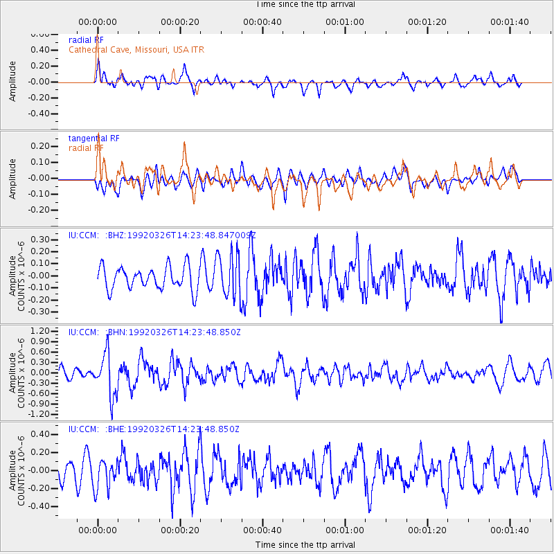
CCM Cathedral Cave, Missouri, USA - Earthquake Result Viewer
*The percent match for this event was below the threshold and hence no stack was calculated.
| Earthquake location: |
Andreanof Islands, Aleutian Is. |
| Earthquake latitude/longitude: |
51.2/-179.7 |
| Earthquake time(UTC): |
1992/03/26 (086) 14:14:12 GMT |
| Earthquake Depth: |
33 km |
| Earthquake Magnitude: |
5.9 MB, 5.6 MS, 5.8 ML |
| Earthquake Catalog/Contributor: |
WHDF/NEIC |
|
| Network: |
IU Global Seismograph Network (GSN - IRIS/USGS) |
| Station: |
CCM Cathedral Cave, Missouri, USA |
| Lat/Lon: |
38.06 N/91.24 W |
| Elevation: |
222 m |
|
| Distance: |
60.6 deg |
| Az: |
64.92 deg |
| Baz: |
313.843 deg |
| Ray Param: |
$rayparam |
*The percent match for this event was below the threshold and hence was not used in the summary stack. |
|
| Radial Match: |
76.101326 % |
| Radial Bump: |
400 |
| Transverse Match: |
57.12917 % |
| Transverse Bump: |
400 |
| SOD ConfigId: |
4480 |
| Insert Time: |
2010-03-04 15:50:31.854 +0000 |
| GWidth: |
2.5 |
| Max Bumps: |
400 |
| Tol: |
0.001 |
|
Signal To Noise
| Channel | StoN | STA | LTA |
| IU:CCM: :BHN:19920326T14:23:48.850Z | 3.7298708 | 6.4037454E-7 | 1.7168813E-7 |
| IU:CCM: :BHE:19920326T14:23:48.850Z | 1.5505755 | 1.5880624E-7 | 1.02417616E-7 |
| IU:CCM: :BHZ:19920326T14:23:48.847009Z | 1.9376069 | 1.8188437E-7 | 9.3870625E-8 |
| Arrivals |
| Ps | |
| PpPs | |
| PsPs/PpSs | |


