You are here: Home > Network List > IU - Global Seismograph Network (GSN - IRIS/USGS) Stations List
> Station CCM Cathedral Cave, Missouri, USA > Earthquake Result Viewer
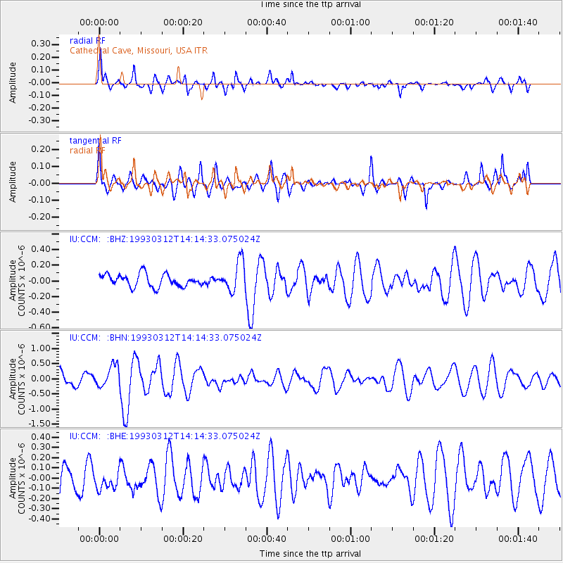
CCM Cathedral Cave, Missouri, USA - Earthquake Result Viewer
*The percent match for this event was below the threshold and hence no stack was calculated.
| Earthquake location: |
Fiji Islands Region |
| Earthquake latitude/longitude: |
-14.3/-178.3 |
| Earthquake time(UTC): |
1993/03/12 (071) 14:01:38 GMT |
| Earthquake Depth: |
33 km |
| Earthquake Magnitude: |
5.9 MB, 6.5 MS |
| Earthquake Catalog/Contributor: |
WHDF/NEIC |
|
| Network: |
IU Global Seismograph Network (GSN - IRIS/USGS) |
| Station: |
CCM Cathedral Cave, Missouri, USA |
| Lat/Lon: |
38.06 N/91.24 W |
| Elevation: |
222 m |
|
| Distance: |
96.4 deg |
| Az: |
52.5 deg |
| Baz: |
256.915 deg |
| Ray Param: |
$rayparam |
*The percent match for this event was below the threshold and hence was not used in the summary stack. |
|
| Radial Match: |
64.31585 % |
| Radial Bump: |
400 |
| Transverse Match: |
67.24352 % |
| Transverse Bump: |
400 |
| SOD ConfigId: |
4480 |
| Insert Time: |
2010-03-04 15:51:02.238 +0000 |
| GWidth: |
2.5 |
| Max Bumps: |
400 |
| Tol: |
0.001 |
|
Signal To Noise
| Channel | StoN | STA | LTA |
| IU:CCM: :BHN:19930312T14:14:33.075024Z | 2.1513784 | 3.69425E-7 | 1.717155E-7 |
| IU:CCM: :BHE:19930312T14:14:33.075024Z | 0.7638942 | 1.0171933E-7 | 1.3315892E-7 |
| IU:CCM: :BHZ:19930312T14:14:33.075024Z | 2.504312 | 2.005344E-7 | 8.0075644E-8 |
| Arrivals |
| Ps | |
| PpPs | |
| PsPs/PpSs | |


