You are here: Home > Network List > IU - Global Seismograph Network (GSN - IRIS/USGS) Stations List
> Station CCM Cathedral Cave, Missouri, USA > Earthquake Result Viewer
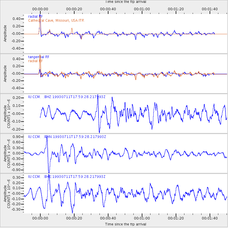
CCM Cathedral Cave, Missouri, USA - Earthquake Result Viewer
*The percent match for this event was below the threshold and hence no stack was calculated.
| Earthquake location: |
Kuril Islands |
| Earthquake latitude/longitude: |
47.6/154.2 |
| Earthquake time(UTC): |
1993/07/11 (192) 17:48:09 GMT |
| Earthquake Depth: |
21 km |
| Earthquake Magnitude: |
5.7 MB, 5.3 MS |
| Earthquake Catalog/Contributor: |
WHDF/NEIC |
|
| Network: |
IU Global Seismograph Network (GSN - IRIS/USGS) |
| Station: |
CCM Cathedral Cave, Missouri, USA |
| Lat/Lon: |
38.06 N/91.24 W |
| Elevation: |
222 m |
|
| Distance: |
76.7 deg |
| Az: |
47.53 deg |
| Baz: |
320.766 deg |
| Ray Param: |
$rayparam |
*The percent match for this event was below the threshold and hence was not used in the summary stack. |
|
| Radial Match: |
71.25238 % |
| Radial Bump: |
375 |
| Transverse Match: |
53.62499 % |
| Transverse Bump: |
400 |
| SOD ConfigId: |
4480 |
| Insert Time: |
2010-03-04 15:51:14.067 +0000 |
| GWidth: |
2.5 |
| Max Bumps: |
400 |
| Tol: |
0.001 |
|
Signal To Noise
| Channel | StoN | STA | LTA |
| IU:CCM: :BHN:19930711T17:59:28.217993Z | 4.3126426 | 3.618474E-7 | 8.390387E-8 |
| IU:CCM: :BHE:19930711T17:59:28.217993Z | 3.412066 | 1.739241E-7 | 5.097325E-8 |
| IU:CCM: :BHZ:19930711T17:59:28.217993Z | 2.0006526 | 9.090296E-8 | 4.5436657E-8 |
| Arrivals |
| Ps | |
| PpPs | |
| PsPs/PpSs | |


