You are here: Home > Network List > CI - Caltech Regional Seismic Network Stations List
> Station TIN Tinemaha, Big Pine, CA, USA > Earthquake Result Viewer
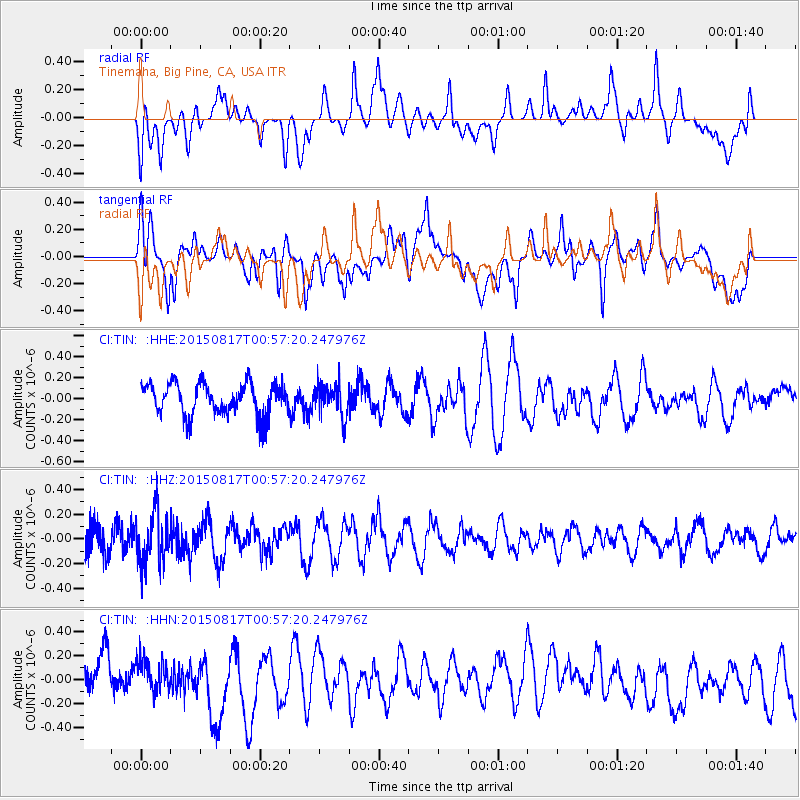
TIN Tinemaha, Big Pine, CA, USA - Earthquake Result Viewer
*The percent match for this event was below the threshold and hence no stack was calculated.
| Earthquake location: |
Bonin Islands, Japan Region |
| Earthquake latitude/longitude: |
27.1/143.7 |
| Earthquake time(UTC): |
2015/08/17 (229) 00:45:42 GMT |
| Earthquake Depth: |
14 km |
| Earthquake Magnitude: |
5.2 MW |
| Earthquake Catalog/Contributor: |
ISC/ISC |
|
| Network: |
CI Caltech Regional Seismic Network |
| Station: |
TIN Tinemaha, Big Pine, CA, USA |
| Lat/Lon: |
37.05 N/118.23 W |
| Elevation: |
1197 m |
|
| Distance: |
80.1 deg |
| Az: |
53.527 deg |
| Baz: |
296.376 deg |
| Ray Param: |
$rayparam |
*The percent match for this event was below the threshold and hence was not used in the summary stack. |
|
| Radial Match: |
40.014744 % |
| Radial Bump: |
400 |
| Transverse Match: |
66.81079 % |
| Transverse Bump: |
400 |
| SOD ConfigId: |
7422571 |
| Insert Time: |
2019-04-20 11:56:12.090 +0000 |
| GWidth: |
2.5 |
| Max Bumps: |
400 |
| Tol: |
0.001 |
|
Signal To Noise
| Channel | StoN | STA | LTA |
| CI:TIN: :HHZ:20150817T00:57:20.247976Z | 1.7016729 | 2.0319818E-7 | 1.1941084E-7 |
| CI:TIN: :HHN:20150817T00:57:20.247976Z | 0.80156124 | 1.4564262E-7 | 1.8169868E-7 |
| CI:TIN: :HHE:20150817T00:57:20.247976Z | 0.9737245 | 1.4779943E-7 | 1.5178773E-7 |
| Arrivals |
| Ps | |
| PpPs | |
| PsPs/PpSs | |


