You are here: Home > Network List > TA - USArray Transportable Network (new EarthScope stations) Stations List
> Station G03D McMinnville, OR, USA > Earthquake Result Viewer
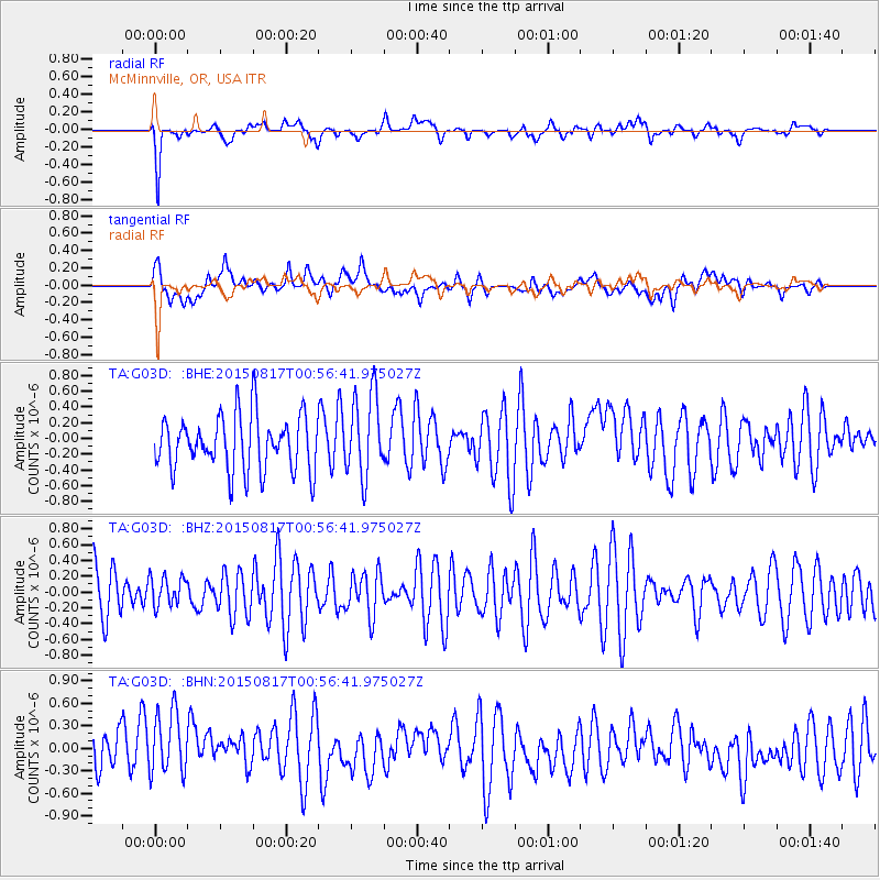
G03D McMinnville, OR, USA - Earthquake Result Viewer
*The percent match for this event was below the threshold and hence no stack was calculated.
| Earthquake location: |
Bonin Islands, Japan Region |
| Earthquake latitude/longitude: |
27.1/143.7 |
| Earthquake time(UTC): |
2015/08/17 (229) 00:45:42 GMT |
| Earthquake Depth: |
14 km |
| Earthquake Magnitude: |
5.2 MW |
| Earthquake Catalog/Contributor: |
ISC/ISC |
|
| Network: |
TA USArray Transportable Network (new EarthScope stations) |
| Station: |
G03D McMinnville, OR, USA |
| Lat/Lon: |
45.21 N/123.26 W |
| Elevation: |
222 m |
|
| Distance: |
73.3 deg |
| Az: |
47.479 deg |
| Baz: |
291.671 deg |
| Ray Param: |
$rayparam |
*The percent match for this event was below the threshold and hence was not used in the summary stack. |
|
| Radial Match: |
54.576225 % |
| Radial Bump: |
400 |
| Transverse Match: |
48.75213 % |
| Transverse Bump: |
400 |
| SOD ConfigId: |
7422571 |
| Insert Time: |
2019-04-20 11:59:13.188 +0000 |
| GWidth: |
2.5 |
| Max Bumps: |
400 |
| Tol: |
0.001 |
|
Signal To Noise
| Channel | StoN | STA | LTA |
| TA:G03D: :BHZ:20150817T00:56:41.975027Z | 0.49484974 | 1.8819277E-7 | 3.8030285E-7 |
| TA:G03D: :BHN:20150817T00:56:41.975027Z | 1.5897309 | 4.7070716E-7 | 2.9609237E-7 |
| TA:G03D: :BHE:20150817T00:56:41.975027Z | 1.5062218 | 5.256218E-7 | 3.4896706E-7 |
| Arrivals |
| Ps | |
| PpPs | |
| PsPs/PpSs | |


