You are here: Home > Network List > US - United States National Seismic Network Stations List
> Station MIAR Mount Ida, Arkansas, USA > Earthquake Result Viewer
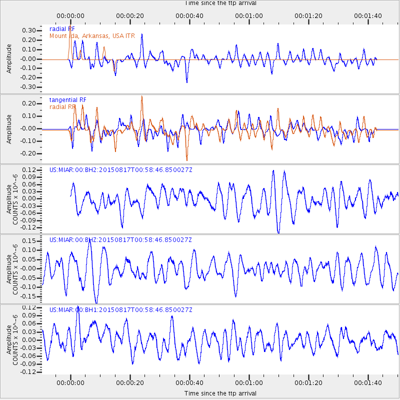
MIAR Mount Ida, Arkansas, USA - Earthquake Result Viewer
*The percent match for this event was below the threshold and hence no stack was calculated.
| Earthquake location: |
Bonin Islands, Japan Region |
| Earthquake latitude/longitude: |
27.1/143.7 |
| Earthquake time(UTC): |
2015/08/17 (229) 00:45:42 GMT |
| Earthquake Depth: |
14 km |
| Earthquake Magnitude: |
5.2 MW |
| Earthquake Catalog/Contributor: |
ISC/ISC |
|
| Network: |
US United States National Seismic Network |
| Station: |
MIAR Mount Ida, Arkansas, USA |
| Lat/Lon: |
34.55 N/93.58 W |
| Elevation: |
207 m |
|
| Distance: |
98.1 deg |
| Az: |
44.561 deg |
| Baz: |
310.743 deg |
| Ray Param: |
$rayparam |
*The percent match for this event was below the threshold and hence was not used in the summary stack. |
|
| Radial Match: |
53.63379 % |
| Radial Bump: |
400 |
| Transverse Match: |
35.320297 % |
| Transverse Bump: |
400 |
| SOD ConfigId: |
7422571 |
| Insert Time: |
2019-04-20 12:00:06.733 +0000 |
| GWidth: |
2.5 |
| Max Bumps: |
400 |
| Tol: |
0.001 |
|
Signal To Noise
| Channel | StoN | STA | LTA |
| US:MIAR:00:BHZ:20150817T00:58:46.850027Z | 1.1430593 | 6.808577E-8 | 5.9564517E-8 |
| US:MIAR:00:BH1:20150817T00:58:46.850027Z | 1.9642739 | 6.292023E-8 | 3.2032307E-8 |
| US:MIAR:00:BH2:20150817T00:58:46.850027Z | 1.234606 | 4.3178506E-8 | 3.497351E-8 |
| Arrivals |
| Ps | |
| PpPs | |
| PsPs/PpSs | |


