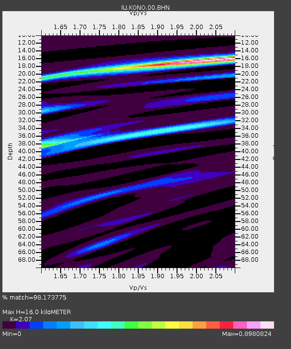
KONO Kongsberg, Norway - Earthquake Result Viewer
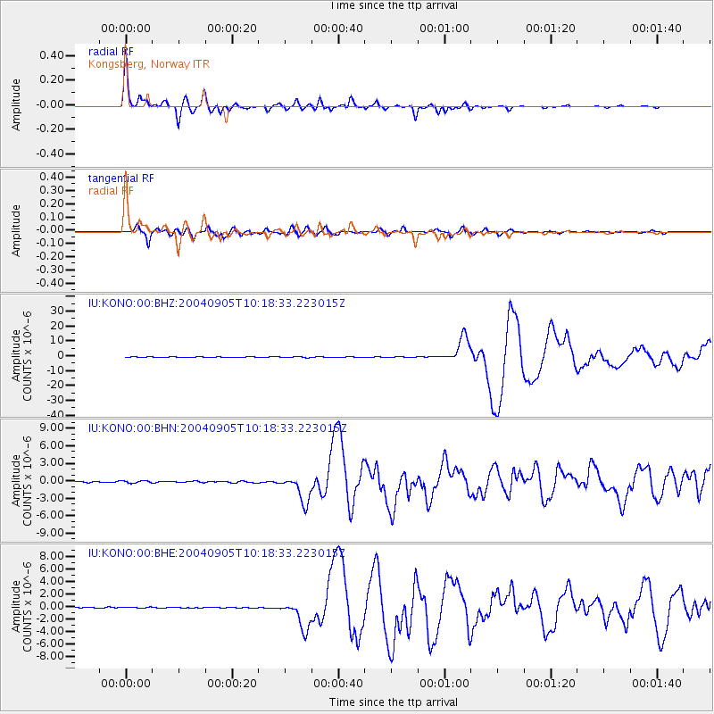
Earthquake location: Near S. Coast Of Western Honshu
Earthquake latitude/longitude: 33.1/136.6
Earthquake time(UTC): 2004/09/05 (249) 10:07:07 GMT
Earthquake Depth: 14 km
Earthquake Magnitude: 6.7 MB, 7.0 MS, 7.2 MW, 7.0 MW
Earthquake Catalog/Contributor: WHDF/NEIC
Network: IU Global Seismograph Network (GSN - IRIS/USGS)
Station: KONO Kongsberg, Norway
Lat/Lon: 59.65 N/9.60 E
Elevation: 216 m
Distance: 77.8 deg
Az: 335.493 deg
Baz: 43.305 deg
Ray Param: 0.050060272
Estimated Moho Depth: 16.0 km
Estimated Crust Vp/Vs: 2.07
Assumed Crust Vp: 6.545 km/s
Estimated Crust Vs: 3.162 km/s
Estimated Crust Poisson's Ratio: 0.35
Radial Match: 98.173775 %
Radial Bump: 380
Transverse Match: 94.939224 %
Transverse Bump: 400
SOD ConfigId: 2459
Insert Time: 2010-03-04 15:51:47.334 +0000
GWidth: 2.5
Max Bumps: 400
Tol: 0.001

Signal To Noise

ChannelStoNSTALTA
IU:KONO:00:BHN:20040905T10:18:33.223015Z2.56075262.0197015E-77.88714E-8
IU:KONO:00:BHE:20040905T10:18:33.223015Z0.64697386.655004E-81.02863574E-7
IU:KONO:00:BHZ:20040905T10:18:33.223015Z3.59521373.8656793E-71.0752293E-7
Arrivals
Ps2.7 SECOND
PpPs7.3 SECOND
PsPs/PpSs10.0 SECOND