You are here: Home > Network List > CI - Caltech Regional Seismic Network Stations List
> Station GLA Glamis, California, USA > Earthquake Result Viewer
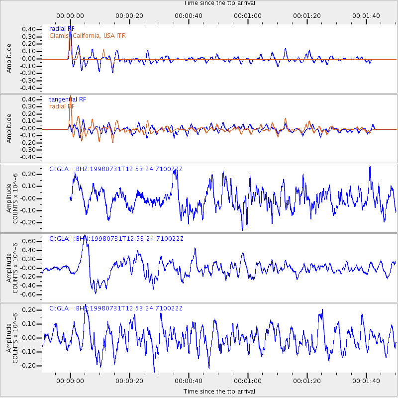
GLA Glamis, California, USA - Earthquake Result Viewer
*The percent match for this event was below the threshold and hence no stack was calculated.
| Earthquake location: |
Southeast Of Loyalty Islands |
| Earthquake latitude/longitude: |
-21.6/169.8 |
| Earthquake time(UTC): |
1998/07/31 (212) 12:40:59 GMT |
| Earthquake Depth: |
33 km |
| Earthquake Magnitude: |
5.9 MS, 5.4 MB, 6.1 UNKNOWN, 6.0 MW |
| Earthquake Catalog/Contributor: |
WHDF/NEIC |
|
| Network: |
CI Caltech Regional Seismic Network |
| Station: |
GLA Glamis, California, USA |
| Lat/Lon: |
33.05 N/114.83 W |
| Elevation: |
627 m |
|
| Distance: |
90.1 deg |
| Az: |
54.346 deg |
| Baz: |
244.196 deg |
| Ray Param: |
$rayparam |
*The percent match for this event was below the threshold and hence was not used in the summary stack. |
|
| Radial Match: |
69.943924 % |
| Radial Bump: |
400 |
| Transverse Match: |
58.844612 % |
| Transverse Bump: |
400 |
| SOD ConfigId: |
4480 |
| Insert Time: |
2010-02-25 23:38:04.748 +0000 |
| GWidth: |
2.5 |
| Max Bumps: |
400 |
| Tol: |
0.001 |
|
Signal To Noise
| Channel | StoN | STA | LTA |
| CI:GLA: :BHN:19980731T12:53:24.710022Z | 5.337201 | 2.7402638E-7 | 5.134271E-8 |
| CI:GLA: :BHE:19980731T12:53:24.710022Z | 1.4704978 | 6.834741E-8 | 4.6479094E-8 |
| CI:GLA: :BHZ:19980731T12:53:24.710022Z | 0.66272247 | 5.2760534E-8 | 7.96118E-8 |
| Arrivals |
| Ps | |
| PpPs | |
| PsPs/PpSs | |


