You are here: Home > Network List > IU - Global Seismograph Network (GSN - IRIS/USGS) Stations List
> Station KONO Kongsberg, Norway > Earthquake Result Viewer
KONO Kongsberg, Norway - Earthquake Result Viewer

| Earthquake location: |
Sea Of Okhotsk |
| Earthquake latitude/longitude: |
53.9/152.9 |
| Earthquake time(UTC): |
2008/07/05 (187) 02:12:04 GMT |
| Earthquake Depth: |
633 km |
| Earthquake Magnitude: |
6.8 MB, 7.7 MW, 7.7 MW |
| Earthquake Catalog/Contributor: |
WHDF/NEIC |
|
| Network: |
IU Global Seismograph Network (GSN - IRIS/USGS) |
| Station: |
KONO Kongsberg, Norway |
| Lat/Lon: |
59.65 N/9.60 E |
| Elevation: |
216 m |
|
| Distance: |
63.0 deg |
| Az: |
340.089 deg |
| Baz: |
23.393 deg |
| Ray Param: |
0.057351846 |
| Estimated Moho Depth: |
36.75 km |
| Estimated Crust Vp/Vs: |
1.71 |
| Assumed Crust Vp: |
6.545 km/s |
| Estimated Crust Vs: |
3.833 km/s |
| Estimated Crust Poisson's Ratio: |
0.24 |
|
| Radial Match: |
97.39136 % |
| Radial Bump: |
400 |
| Transverse Match: |
90.98848 % |
| Transverse Bump: |
400 |
| SOD ConfigId: |
2504 |
| Insert Time: |
2010-03-04 15:52:30.428 +0000 |
| GWidth: |
2.5 |
| Max Bumps: |
400 |
| Tol: |
0.001 |
|
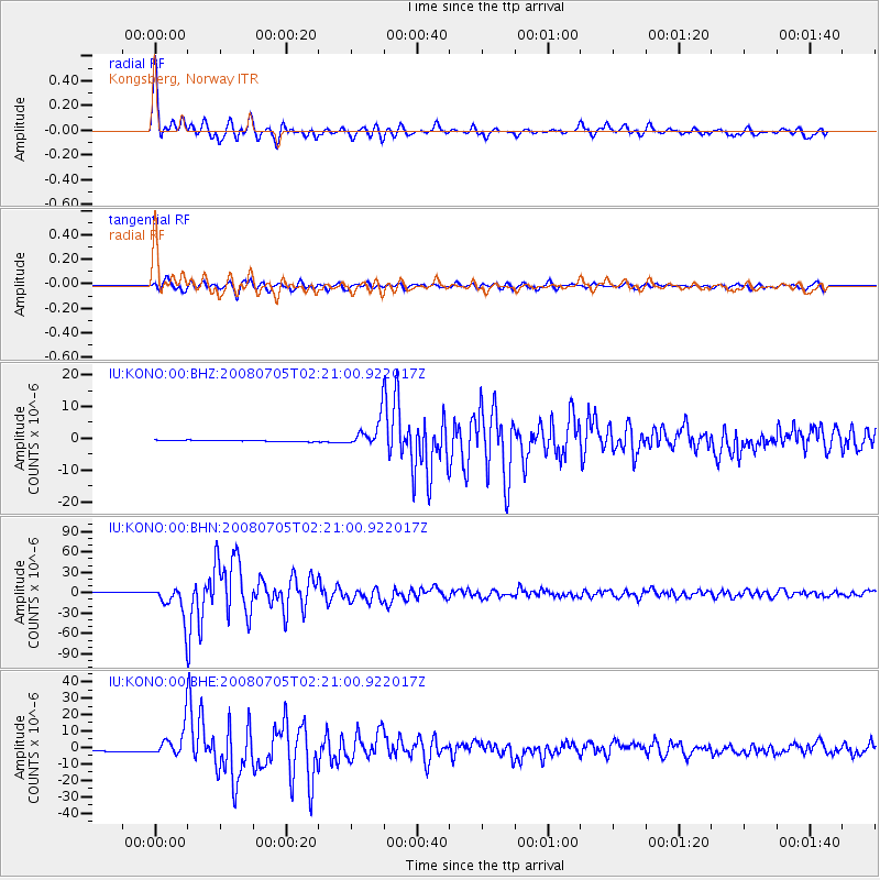
Signal To Noise
| Channel | StoN | STA | LTA |
| IU:KONO:00:BHN:20080705T02:21:00.922017Z | 29.245476 | 2.531899E-5 | 8.657404E-7 |
| IU:KONO:00:BHE:20080705T02:21:00.922017Z | 20.219814 | 9.568394E-6 | 4.7321868E-7 |
| IU:KONO:00:BHZ:20080705T02:21:00.922017Z | 19.449368 | 4.4390026E-6 | 2.282338E-7 |
| Arrivals |
| Ps | 4.1 SECOND |
| PpPs | 15 SECOND |
| PsPs/PpSs | 19 SECOND |


