You are here: Home > Network List > CI - Caltech Regional Seismic Network Stations List
> Station GLA Glamis, California, USA > Earthquake Result Viewer
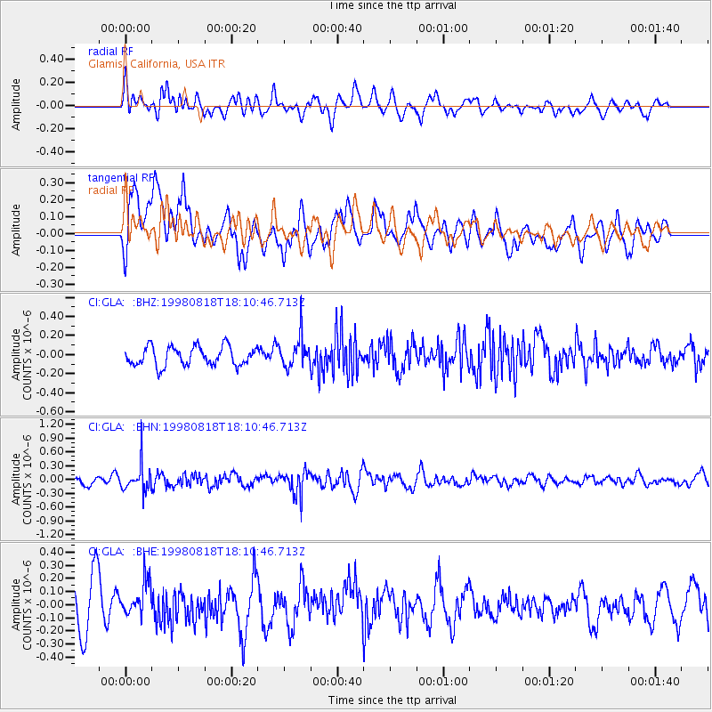
GLA Glamis, California, USA - Earthquake Result Viewer
*The percent match for this event was below the threshold and hence no stack was calculated.
| Earthquake location: |
Kuril Islands |
| Earthquake latitude/longitude: |
45.9/149.1 |
| Earthquake time(UTC): |
1998/08/18 (230) 18:00:12 GMT |
| Earthquake Depth: |
116 km |
| Earthquake Magnitude: |
5.6 UNKNOWN, 5.4 MB, 5.6 MW |
| Earthquake Catalog/Contributor: |
WHDF/NEIC |
|
| Network: |
CI Caltech Regional Seismic Network |
| Station: |
GLA Glamis, California, USA |
| Lat/Lon: |
33.05 N/114.83 W |
| Elevation: |
627 m |
|
| Distance: |
71.0 deg |
| Az: |
62.069 deg |
| Baz: |
312.671 deg |
| Ray Param: |
$rayparam |
*The percent match for this event was below the threshold and hence was not used in the summary stack. |
|
| Radial Match: |
55.24857 % |
| Radial Bump: |
400 |
| Transverse Match: |
57.266388 % |
| Transverse Bump: |
400 |
| SOD ConfigId: |
4480 |
| Insert Time: |
2010-02-25 23:38:10.256 +0000 |
| GWidth: |
2.5 |
| Max Bumps: |
400 |
| Tol: |
0.001 |
|
Signal To Noise
| Channel | StoN | STA | LTA |
| CI:GLA: :BHN:19980818T18:10:46.713Z | 3.4337559 | 3.021452E-7 | 8.7992625E-8 |
| CI:GLA: :BHE:19980818T18:10:46.713Z | 0.9628913 | 1.3815486E-7 | 1.434792E-7 |
| CI:GLA: :BHZ:19980818T18:10:46.713Z | 1.6001552 | 1.589707E-7 | 9.9347055E-8 |
| Arrivals |
| Ps | |
| PpPs | |
| PsPs/PpSs | |


