You are here: Home > Network List > IU - Global Seismograph Network (GSN - IRIS/USGS) Stations List
> Station KONO Kongsberg, Norway > Earthquake Result Viewer
KONO Kongsberg, Norway - Earthquake Result Viewer

| Earthquake location: |
Kuril Islands |
| Earthquake latitude/longitude: |
44.7/149.5 |
| Earthquake time(UTC): |
1992/07/10 (192) 09:31:26 GMT |
| Earthquake Depth: |
11 km |
| Earthquake Magnitude: |
6.1 MB, 6.5 MS |
| Earthquake Catalog/Contributor: |
WHDF/NEIC |
|
| Network: |
IU Global Seismograph Network (GSN - IRIS/USGS) |
| Station: |
KONO Kongsberg, Norway |
| Lat/Lon: |
59.65 N/9.60 E |
| Elevation: |
216 m |
|
| Distance: |
71.0 deg |
| Az: |
339.756 deg |
| Baz: |
29.092 deg |
| Ray Param: |
0.054638837 |
| Estimated Moho Depth: |
38.25 km |
| Estimated Crust Vp/Vs: |
1.64 |
| Assumed Crust Vp: |
6.545 km/s |
| Estimated Crust Vs: |
3.997 km/s |
| Estimated Crust Poisson's Ratio: |
0.20 |
|
| Radial Match: |
93.57317 % |
| Radial Bump: |
400 |
| Transverse Match: |
71.4199 % |
| Transverse Bump: |
400 |
| SOD ConfigId: |
16938 |
| Insert Time: |
2010-03-04 15:53:11.319 +0000 |
| GWidth: |
2.5 |
| Max Bumps: |
400 |
| Tol: |
0.001 |
|
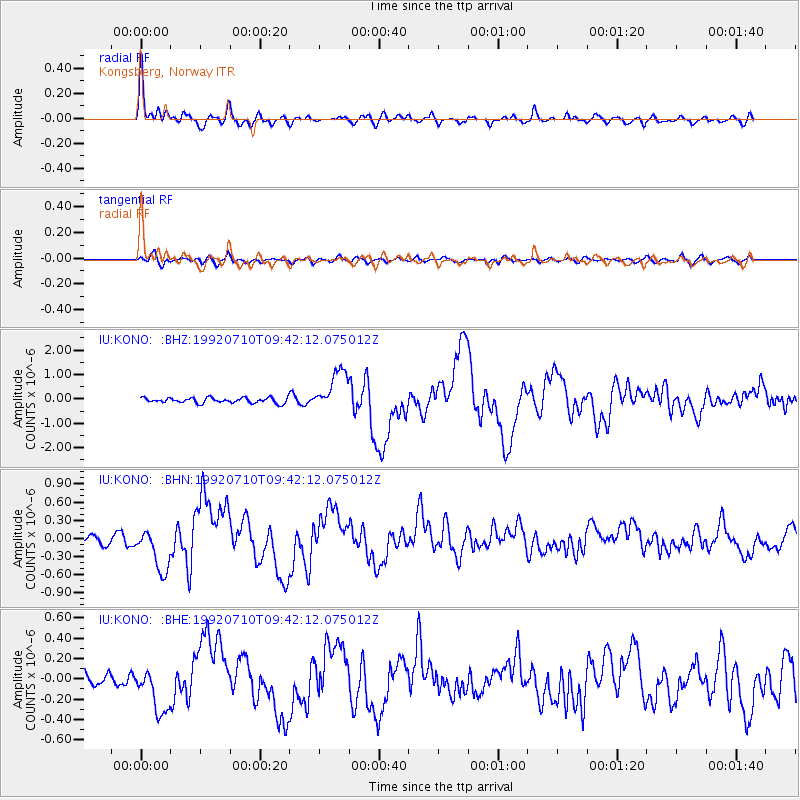
Signal To Noise
| Channel | StoN | STA | LTA |
| IU:KONO: :BHN:19920710T09:42:12.075012Z | 4.830693 | 3.6127344E-7 | 7.478709E-8 |
| IU:KONO: :BHE:19920710T09:42:12.075012Z | 3.1603112 | 2.2691745E-7 | 7.180225E-8 |
| IU:KONO: :BHZ:19920710T09:42:12.075012Z | 7.7090263 | 8.3138E-7 | 1.07845004E-7 |
| Arrivals |
| Ps | 3.9 SECOND |
| PpPs | 15 SECOND |
| PsPs/PpSs | 19 SECOND |


