You are here: Home > Network List > TA - USArray Transportable Network (new EarthScope stations) Stations List
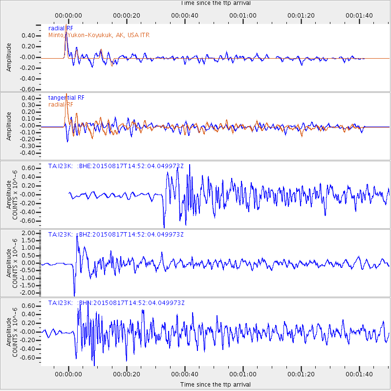
> Station I23K Minto, Yukon-Koyukuk, AK, USA > Earthquake Result Viewer
I23K Minto, Yukon-Koyukuk, AK, USA - Earthquake Result Viewer
| Earthquake location: |
Mariana Islands Region |
| Earthquake latitude/longitude: |
21.9/146.6 |
| Earthquake time(UTC): |
2015/08/17 (229) 14:42:32 GMT |
| Earthquake Depth: |
3.1 km |
| Earthquake Magnitude: |
5.6 MWB |
| Earthquake Catalog/Contributor: |
NEIC PDE/NEIC COMCAT |
|
| Network: |
TA USArray Transportable Network (new EarthScope stations) |
| Station: |
I23K Minto, Yukon-Koyukuk, AK, USA |
| Lat/Lon: |
65.15 N/149.36 W |
| Elevation: |
149 m |
|
| Distance: |
59.4 deg |
| Az: |
26.176 deg |
| Baz: |
255.745 deg |
| Ray Param: |
0.06220976 |
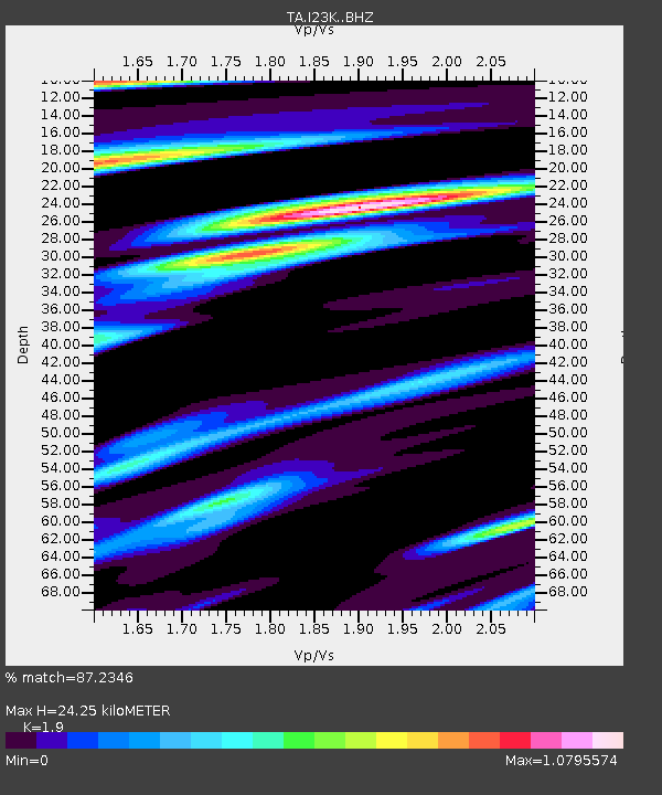
| Estimated Moho Depth: |
24.25 km |
| Estimated Crust Vp/Vs: |
1.90 |
| Assumed Crust Vp: |
6.566 km/s |
| Estimated Crust Vs: |
3.456 km/s |
| Estimated Crust Poisson's Ratio: |
0.31 |
|
| Radial Match: |
87.2346 % |
| Radial Bump: |
400 |
| Transverse Match: |
74.04281 % |
| Transverse Bump: |
400 |
| SOD ConfigId: |
7422571 |
| Insert Time: |
2019-04-20 12:09:11.940 +0000 |
| GWidth: |
2.5 |
| Max Bumps: |
400 |
| Tol: |
0.001 |
|
Signal To Noise
| Channel | StoN | STA | LTA |
| TA:I23K: :BHZ:20150817T14:52:04.049973Z | 16.436058 | 8.273136E-7 | 5.033528E-8 |
| TA:I23K: :BHN:20150817T14:52:04.049973Z | 6.2459803 | 2.795306E-7 | 4.4753683E-8 |
| TA:I23K: :BHE:20150817T14:52:04.049973Z | 7.332443 | 2.970749E-7 | 4.0515133E-8 |
| Arrivals |
| Ps | 3.5 SECOND |
| PpPs | 10 SECOND |
| PsPs/PpSs | 14 SECOND |


