You are here: Home > Network List > CI - Caltech Regional Seismic Network Stations List
> Station GLA Glamis, Glamis, CA, USA > Earthquake Result Viewer
GLA Glamis, Glamis, CA, USA - Earthquake Result Viewer
*The percent match for this event was below the threshold and hence no stack was calculated.
| Earthquake location: |
Mariana Islands |
| Earthquake latitude/longitude: |
19.1/145.8 |
| Earthquake time(UTC): |
2008/12/02 (337) 12:31:43 GMT |
| Earthquake Depth: |
137 km |
| Earthquake Magnitude: |
5.9 MB, 5.9 MW, 5.9 MW |
| Earthquake Catalog/Contributor: |
WHDF/NEIC |
|
| Network: |
CI Caltech Regional Seismic Network |
| Station: |
GLA Glamis, Glamis, CA, USA |
| Lat/Lon: |
33.05 N/114.83 W |
| Elevation: |
610 m |
|
| Distance: |
87.3 deg |
| Az: |
56.039 deg |
| Baz: |
290.959 deg |
| Ray Param: |
$rayparam |
*The percent match for this event was below the threshold and hence was not used in the summary stack. |
|
| Radial Match: |
61.91915 % |
| Radial Bump: |
400 |
| Transverse Match: |
68.17533 % |
| Transverse Bump: |
322 |
| SOD ConfigId: |
2658 |
| Insert Time: |
2010-02-25 23:38:13.501 +0000 |
| GWidth: |
2.5 |
| Max Bumps: |
400 |
| Tol: |
0.001 |
|
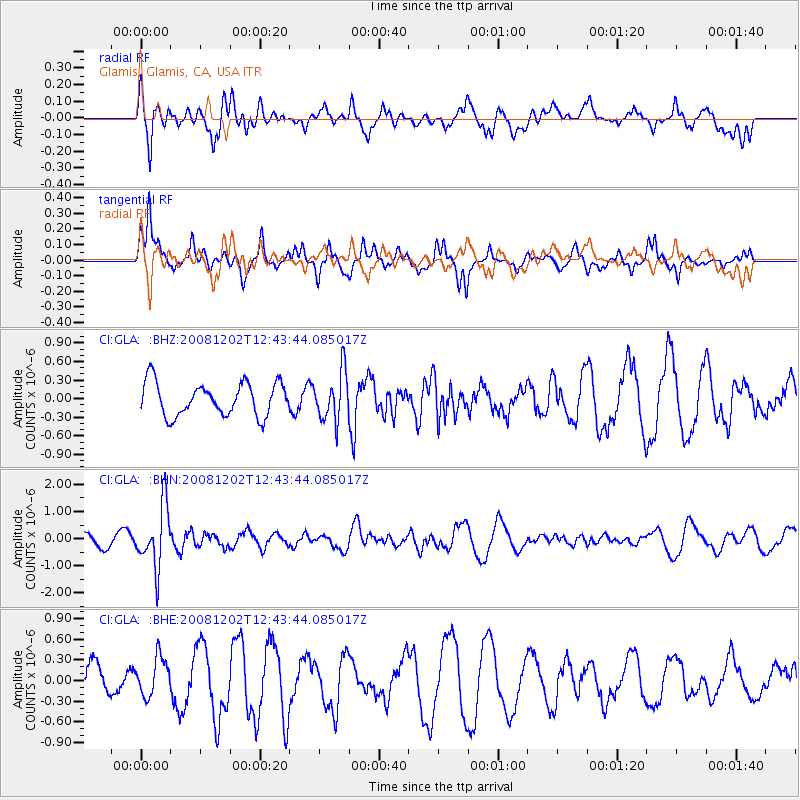
Signal To Noise
| Channel | StoN | STA | LTA |
| CI:GLA: :BHN:20081202T12:43:44.085017Z | 3.633215 | 1.1302027E-6 | 3.110751E-7 |
| CI:GLA: :BHE:20081202T12:43:44.085017Z | 0.6854524 | 2.772925E-7 | 4.0453935E-7 |
| CI:GLA: :BHZ:20081202T12:43:44.085017Z | 1.4737833 | 3.898373E-7 | 2.6451468E-7 |
| Arrivals |
| Ps | |
| PpPs | |
| PsPs/PpSs | |


