You are here: Home > Network List > TA - USArray Transportable Network (new EarthScope stations) Stations List
> Station M26K Nabesna, AK, USA > Earthquake Result Viewer
M26K Nabesna, AK, USA - Earthquake Result Viewer
| Earthquake location: |
Mariana Islands Region |
| Earthquake latitude/longitude: |
21.9/146.6 |
| Earthquake time(UTC): |
2015/08/17 (229) 14:42:32 GMT |
| Earthquake Depth: |
3.1 km |
| Earthquake Magnitude: |
5.6 MWB |
| Earthquake Catalog/Contributor: |
NEIC PDE/NEIC COMCAT |
|
| Network: |
TA USArray Transportable Network (new EarthScope stations) |
| Station: |
M26K Nabesna, AK, USA |
| Lat/Lon: |
62.40 N/143.00 W |
| Elevation: |
888 m |
|
| Distance: |
61.7 deg |
| Az: |
29.876 deg |
| Baz: |
263.268 deg |
| Ray Param: |
0.06071657 |
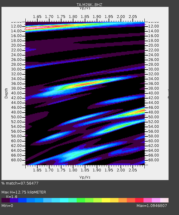
| Estimated Moho Depth: |
12.75 km |
| Estimated Crust Vp/Vs: |
1.60 |
| Assumed Crust Vp: |
6.566 km/s |
| Estimated Crust Vs: |
4.104 km/s |
| Estimated Crust Poisson's Ratio: |
0.18 |
|
| Radial Match: |
87.56477 % |
| Radial Bump: |
400 |
| Transverse Match: |
79.32819 % |
| Transverse Bump: |
400 |
| SOD ConfigId: |
7422571 |
| Insert Time: |
2019-04-20 12:09:27.857 +0000 |
| GWidth: |
2.5 |
| Max Bumps: |
400 |
| Tol: |
0.001 |
|

Signal To Noise
| Channel | StoN | STA | LTA |
| TA:M26K: :BHZ:20150817T14:52:19.549973Z | 8.003884 | 4.5239787E-7 | 5.6522293E-8 |
| TA:M26K: :BHN:20150817T14:52:19.549973Z | 4.010199 | 1.6588774E-7 | 4.1366462E-8 |
| TA:M26K: :BHE:20150817T14:52:19.549973Z | 4.7882047 | 2.1884489E-7 | 4.5705E-8 |
| Arrivals |
| Ps | 1.2 SECOND |
| PpPs | 4.8 SECOND |
| PsPs/PpSs | 6.0 SECOND |


